
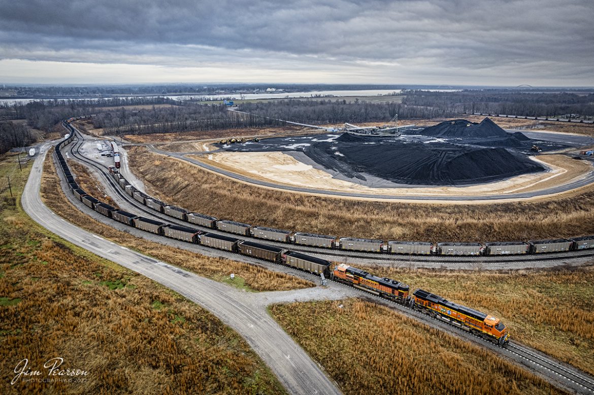
BNSF 25th Anniversary unit 6078 enters the four rivers loop at West Paducah, KY
BNSF 25th Anniversary unit 6078 and 9282 bring up the rear of a loaded coal train as DPUs as they head into the loop at four Rivers Terminal at West Paducah, Kentucky on December 29th, 2021.
Four Rivers Marine Terminal (FRT) is owned by SCH Services, LLC, and located at West Paducah, KY at Ohio River mile marker 943. Four Rivers has an annual throughput capacity of 10 MM tons. Illinois Basin and Powder River Basin coals are transferred from railcar to barge here.
According to SCH Services Website: It is primarily designed as a direct train-to-barge transfer terminal, FRT offers its customers an unparalleled combination of access to major waterways and multiple Class I railroads. Our connection to the Paducah and Illinois Railroad gives FRT direct access to the BNSF, CN, and PAL railroads. Considering only the modern Olmsted Lock and Dam separates the terminal from the Mississippi River, FRT presents a unique option for rail-bound shipments destined for both southeastern customers and export through New Orleans. Four Rivers Terminal boasts a double, 150-car rail loop, coupled with a material handling system capable of transloading 4,000 tons of dry bulk material per hour.
Tech Info: DJI Mavic Air 2 Drone, RAW, 4.5mm (24mm equivalent lens) f/2.8, 1/160, ISO 130.
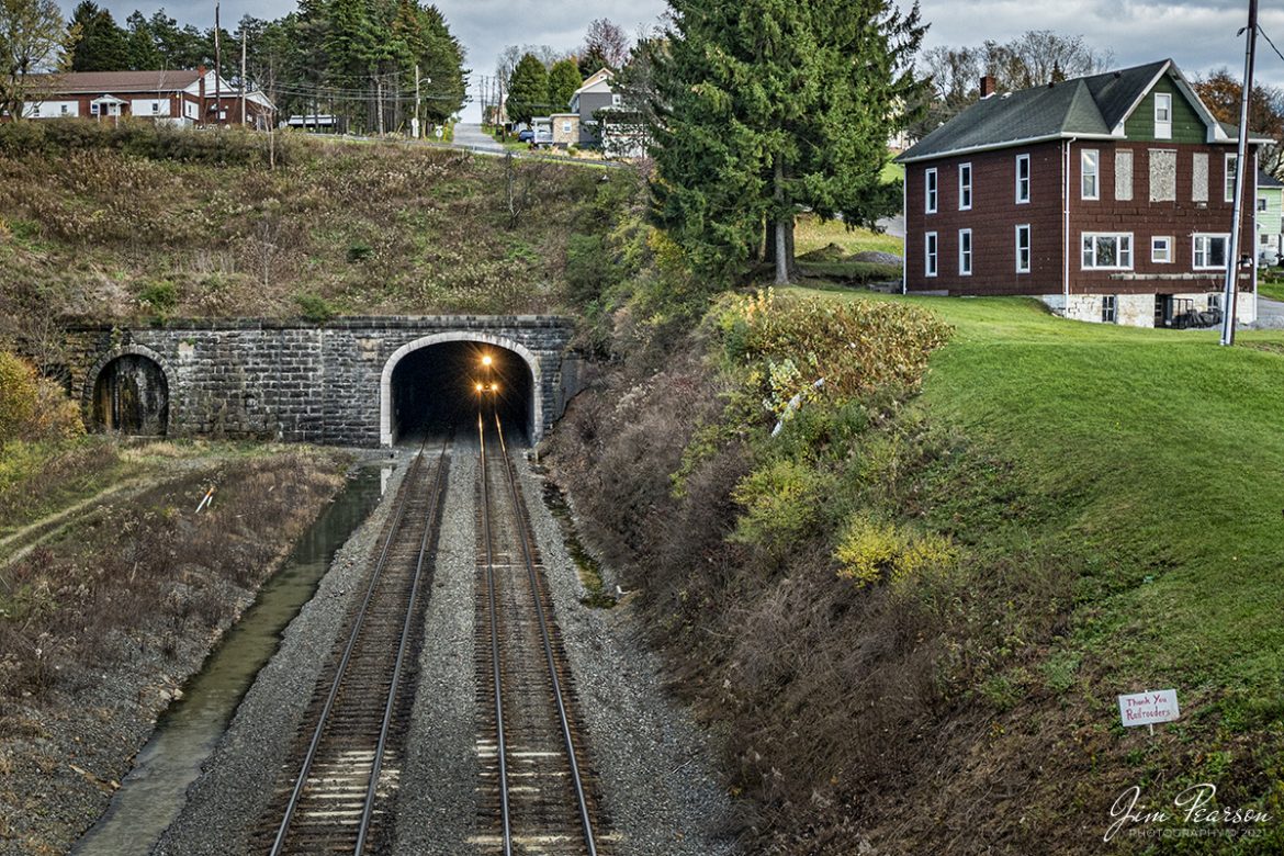
Norfolk Southern 7603 and 8410 approach the western entrance to the Gallitzin Tunnel at Gallitzin, Pennsylvania
Norfolk Southern 7603 and 8410 approach the western entrance to the Gallitzin Tunnel at Gallitzin, Pennsylvania as they head west on the Norfolk Southern Pittsburgh Line on November 3rd, 2021, with an empty coal train.
According to Wikipedia: The Gallitzin Tunnels in Gallitzin, Pennsylvania, are a set of three adjacent tunnels through the Allegheny Mountains in western Pennsylvania. They were completed in 1854, 1855, and 1902 by the Pennsylvania Railroad as part of the cross-state route that includes the nearby Horseshoe Curve to the east. Their ownership has since passed to Penn Central Transportation Company, then to Conrail, and most recently to the Norfolk Southern Railway. The tunnels are currently used by Norfolk Southern freight trains and Amtrak Pennsylvanian passenger trains.
The first tunnel, which is the middle of the three bores through the mountain, was built by the PRR from 1851 to 1854. Originally named “Summit” Tunnel, it is 3,612 feet long at an elevation of 2,167 feet above mean sea level and is known today as the Allegheny Tunnel.
The second tunnel, the southernmost of the bores, was constructed by the Commonwealth of Pennsylvania from 1852 to 1855 as part of the New Portage Railroad (NPRR). In 1857, the PRR bought the New Portage Railroad from the Commonwealth and appropriated the “Allegheny” name for its “Summit” tunnel. The PRR took the New Portage Tunnel out of service shortly thereafter. In the 1890s, it was expanded to two tracks and used as the primary route for eastbound traffic.
The third tunnel, the Gallitzin Tunnel, was begun in 1902 and opened in 1904 immediately to the north of the Allegheny Tunnel.
In the early 1990s, Conrail (with money from the Commonwealth of Pennsylvania) enlarged the Allegheny and New Portage Tunnels to accommodate double-stack container on flatcar (COFC) trains. The New Portage Tunnel was opened for eastbound COFC traffic in 1993. The Allegheny Tunnel was enlarged from its original 1854 cross-section to contain two tracks for that could be used for double-stack rail transport in either direction. The work was completed in September 1995, and the Gallitzin Tunnel (which was not enlarged) was taken out of service.
Tech Info: Nikon D800, RAW, Nikon 10-24 @ 22mm, f/4.5, 1/800, ISO 560.
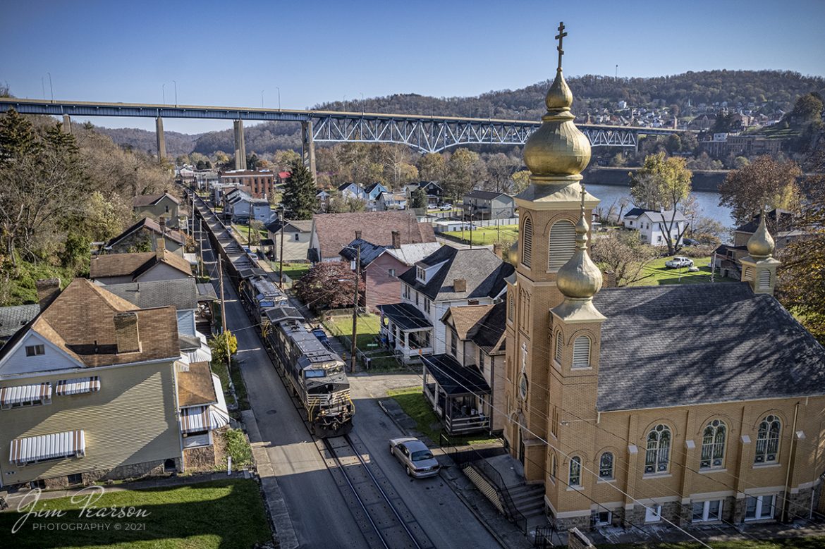
Norfolk Southern 4290 leads an empty coal train street running at Brownsville, PA
Norfolk Southern 4290 leads an empty coal train north down Main Street past the Holy Resurrection Orthodox Church at Brownsville, Pennsylvania on the NS Mon line. I never knew there was street running in this area until fellow railfan Ben Sutton put me onto this spot! Came away from here with several shots that I love and will be posting over the next weeks! Thanks Ben!
According to Wikipedia: The Mon Line is an 85-mile-long Norfolk Southern rail line which runs along the Monongahela River for most of its route.
The predecessor of this line is the Pittsburgh, Virginia and Charleston Railroad. The northern portion (Pittsburgh to West Brownsville) of the line is the former main line of the Monongahela Division of the Pennsylvania Railroad, and the southern portion (West Brownsville to Waynesburg) was once part of the Monongahela Railway’s Waynesburg Southern Branch.
Its northern terminus was formerly at the junction with the Panhandle Route at the Panhandle Bridge in Pittsburgh, and its southern terminus was near Brownsville, Pennsylvania where it had a connection to the Monongahela Railway.
Conrail transferred the West Brownsville to Waynesburg trackage from the Waynesburg Southern Branch to the former main line of the PRR Monongahela Division and it became the new Mon Line.
Tech Info: DJI Mavic Air 2S Drone, RAW, 22mm, f/2.8, 1/1250, ISO 110.
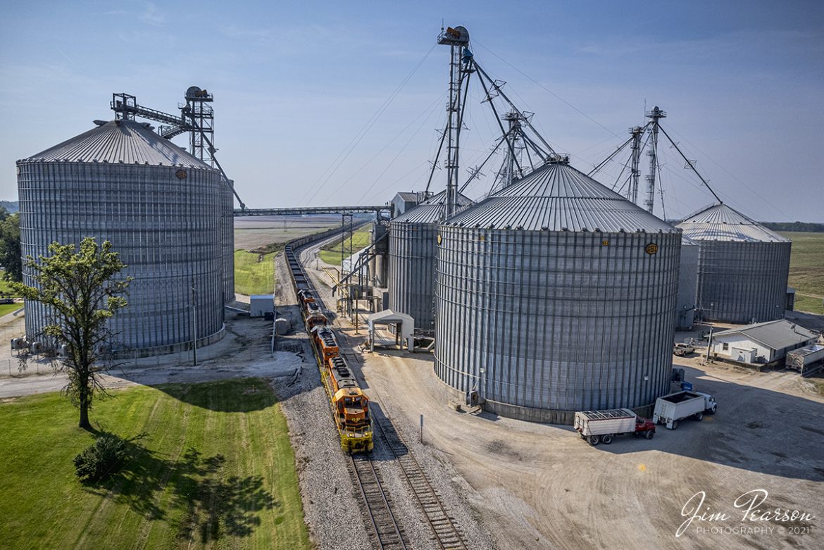
Indiana Southern Railroad passes Kent Grain as it heads south at Plainville, Indiana
Indiana Southern Railroad (ISRR) 3371, 3388, 3372 and 3387, lead an empty coal train north, past Kent Grain in Plainville, Indiana on October 9th, 2021. The crew will take the train to Elnora, IN where they tie it down for the Indiana Railroad (INRD) to pick up. The INRD crew will then take the train on their railroad to Bear Run Mine near Dugger, IN for another load of coal for the Petersburg Generating Station at Petersburg, IN.
According to Wikipedia: The Indiana Southern Railroad (reporting mark ISRR) is a short line or Class III railroad operating in the United States state of Indiana. It began operations in 1992 as a RailTex property and was acquired by RailAmerica in 2000. RailAmerica was itself acquired by Genesee & Wyoming in December 2012. They operate 186 miles of track from Indianapolis to Evansville, Indiana.
Tech Info: DJI Mavic Air 2S Drone, RAW, 22mm, f/2.8, 1/4000, ISO 100.
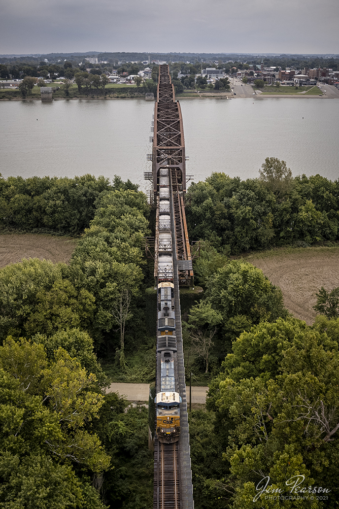
Trackside in Southern Indiana with UP Dave on the CSX Henderson Subdivision
On October 13th, 2021, I spent most of the day trackside with Virtual Railfan Moderator UP Dave, (David Siteman) showing him around some of my favorite spots in Western Kentucky and southern Indiana. We both had a great day trackside, and it was finally great to meet him in person! If youre not already a member, check out Virtual Railfan Live and Virtual Railfan Lounge here on Facebook!
Here we find CSXT 5110 as it leads empty coal train CSX E300-12, a Stilesboro, GA (Plant Bowen) to Effingham, IL (CN) train, across the Ohio River bridge from Henderson, KY on the way north to Evansville, IN on the Henderson Subdivision. This bridge was originally built by the Louisville and Nashville Railroad and was intended to be double tracked eventually, but it never happened.
According to Wikipedia: The Bridge spans the Ohio River between Henderson, Kentucky and Vanderburgh County, Indiana. The bridge is owned by the CSX Transportation.
The original bridge was constructed in 1884 to 1885 by the Louisville and Nashville Railroad at a cost of $2,000,000. The single-tracked bridge was approximately 3,686 feet (1,123 m) long, and its longest span, at 525 feet (160 m), was reputed to be the longest trestle span in the world at that time. The bridge ran from the northern edge of Main Street in Henderson to the low water mark on the Indiana side, resting on 15 stone piers. It was designed to carry two 118,000-pound (54,000 kg) engines followed by 60,000-pound (27,000 kg) coal tenders, and its maximum uniform load capacity was 2,500 pounds per foot (3,700 kg/m). A crowd of 8,000 watched the first train cross the bridge on July 13, 1885.
Prior to the opening of the bridge, railroad passengers and freight had to be transferred to a ferry for the river crossing. The bridge reduced the travel time by several hours.
By 1930 the volume and weight of train traffic were taxing the capabilities of the original bridge. Construction of a new bridge just upstream of the old one began in May 1931. The new bridge, costing over $3,000,000, opened on December 31, 1932. Including its approaches, It is 12,123 feet (3,695 m) long, and its span over the main channel is 648 feet (198 m) long. The demolition of the old bridge, using dynamite, was completed on December 11, 1933.
Tech Info: DJI Mavic Air 2S Drone, RAW, 22mm, f/2.8, 1/1000, ISO 100.

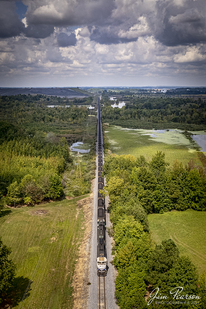
Paducah and Louisville 4504 and 4522 LGE coal train Northbound at Madisonville, KY
Paducah and Louisville 4504 and 4522 (UK paint scheme) roll across Interstate 69 at Madisonville, Kentucky as they head north with their loaded coal train, bound for the Louisville Gas and Electric power plant in the Kosmosdale neighborhood of Louisville, Kentucky on October 5th, 2021.
Tech Info: DJI Mavic Air 2S Drone, RAW, 22mm, f/2.8, 1/2000, ISO 120.
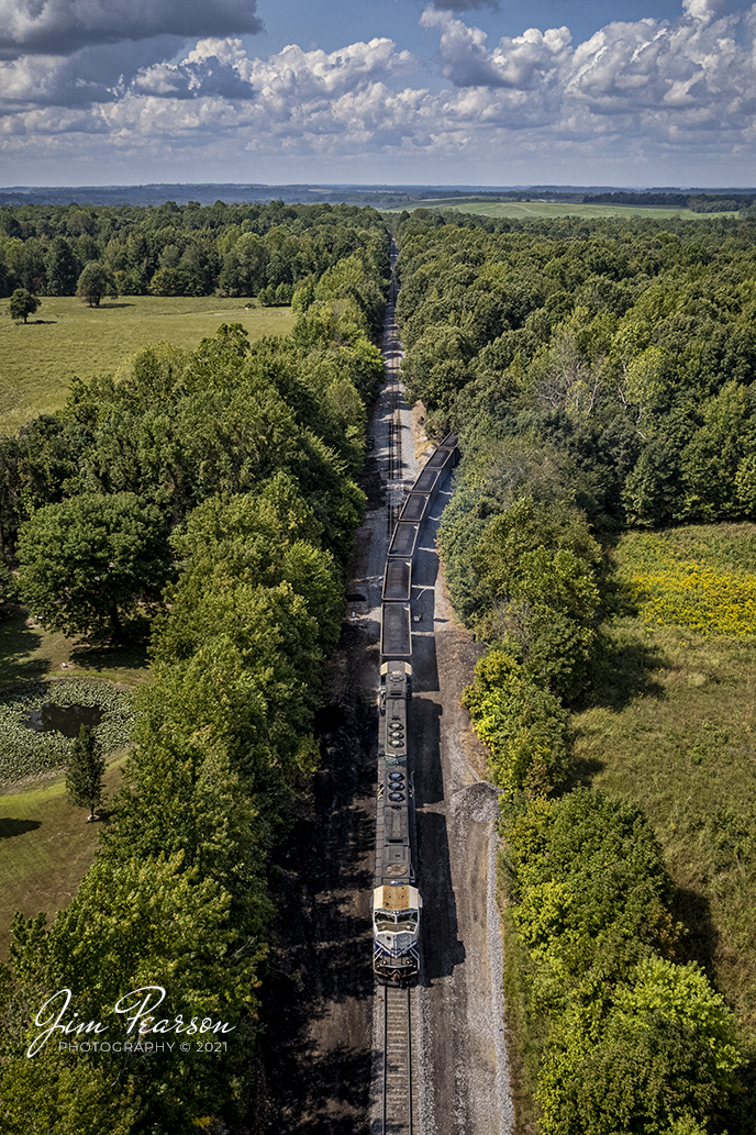
Paducah and Louisville Railway University of Kentucky Locomotive 4522 departs Warrior Coal
Paducah and Louisville Railway University of Kentucky Locomotive 4522 and PAL 4504 lead a northbound loaded Louisville Gas and Electric Coal train through a wetlands area as they depart on the Warrior Coal Mine lead, just west of Madisonville, Kentucky, on their way north to Louisville under partly cloudy summer skies.
Tech Info: DJI Mavic Air 2S Drone, RAW, 22mm, f/2.8, 1/2000, ISO 110, September 13, 2021.
Paducah and Louisville LGE coal train at Madisonville, KY
The Paducah and Louisville (PAL) LGE coal train, with UK 4522 locomotive leading, pulls off the Warrior Coal Mine lead onto the PAL main as they approach West Yard at Madisonville, Ky. From here they begin their run to the Louisville Gas and Electric power plant in the Kosmosdale neighborhood of Louisville, Kentucky.
Tech Info: DJI Mavic Air 2S Drone, RAW, 22mm, f/2.8, 1/2000, ISO 130, September 13, 2021.
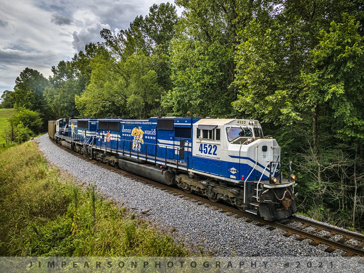
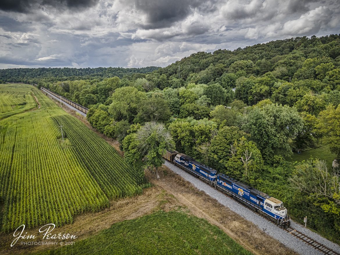
PAL LG1 loaded coal headed north approaching Rockport, Kentucky
Paducah and Louisville University of Kentucky locomotives 4522 and 2012 lead the Louisville Gas & Electric loaded coal train north as they round a curve leading into Rockport, Kentucky, on its way to the Louisville Gas and Electric power plant in the Kosmosdale neighborhood of Louisville, Kentucky.
Tech Info: Wide Photo: DJI Mavic Air 2 Drone, RAW, 4.5mm (24mm equivalent lens) f/2.8, 1/640, ISO 100, August 17, 2021.
PAL loaded coal headed north through the valley at Spring Lick, Kentucky
Paducah and Louisville University of Kentucky locomotives 4522 and 2012 lead the Louisville Gas & Electric loaded coal train north through the valley at Spring Lick, Kentucky on its way to the Louisville Gas and Electric power plant in the Kosmosdale neighborhood of Louisville, Kentucky.
From the web: “The Paducah and Louisville Railway (reporting marks, PAL) is a regional operation based in Paducah, Kentucky that began operations in 1986 over ex-Illinois Central trackage.
Today it utilizes over 260 miles of railroad and is owned by P&L Transportation (previously known as Four Rivers Transportation), which itself is controlled by CSX Corporation (parent company to CSX Transportation, its railroad division).
The P&L also operates the Appalachian & Ohio in West Virginia. This road is predominately a coal hauler, which leases CSX’s Cowen Subdivision, a former Baltimore & Ohio corridor.”
Tech Info: Wide Photo: DJI Mavic Air 2 Drone, RAW, 4.5mm (24mm equivalent lens) f/2.8, 1/640, ISO 100, August 17, 2021.
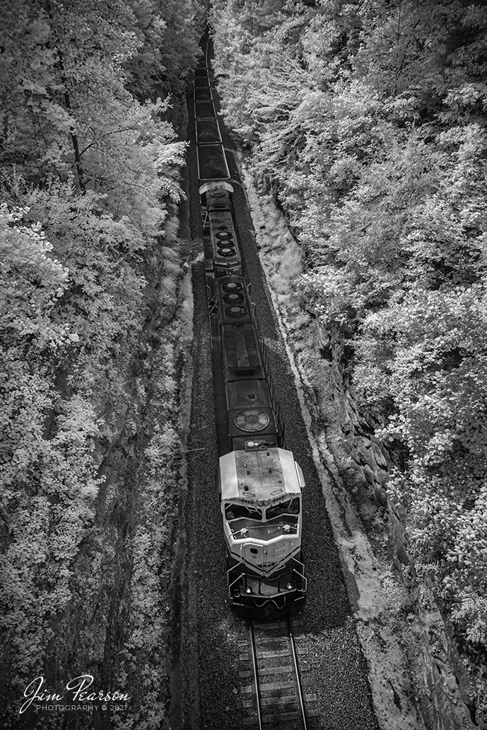
A view from the top of PAL LG1 Northbound to Louisville, Kentucky
An infrared shot (taken the now old fashion way) from the overpass on highway 85, a few miles south of Central City, Kentucky as Paducah and Louisville Railways Louisville Gas and Electric loaded coal train, LG1, passes through the cut there on its way north with another load for the power plant, as PAL University of Kentucky locomotives, 4522 and 2012 lead the way.
Tech Info: Fuji XT-1, RAW, Converted to 720nm B&W IR, Fuji 18-55 @18mm, f/2.8, 1/500, ISO 200, August 13, 2021.
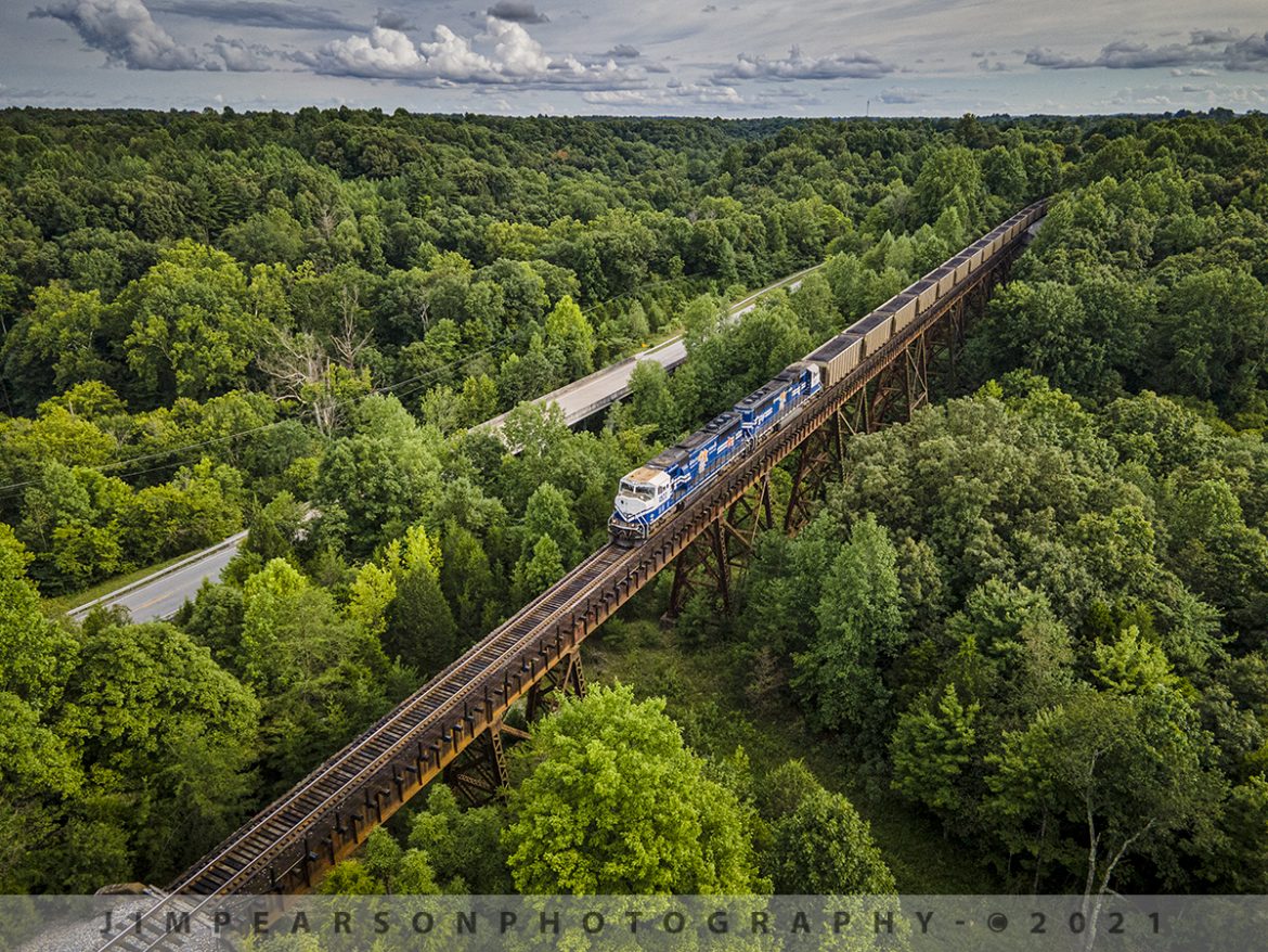
Paducah and Louisville Railway loaded coal at Big Clifty, Kentucky
Paducah and Louisville University of Kentucky locomotives 4522 and 2012 lead the Louisville Gas & Electric loaded coal train across the trestle at Big Clifty, Kentucky as it heads north along highway 62 on its way to the Louisville Gas and Electric power plant in the Kosmosdale neighborhood of Louisville, Kentucky.
According to their website: “The Mill Creek Generation Station is LG&E’s largest coal-fired power plant, with a generating capacity of 1,465 megawatts. Mill Creek sits on 544 acres in southwest Jefferson County, Ky.
The late 1960s and early 1970s saw an unprecedented increase in the construction of new industrial, commercial, and residential facilities in the Louisville area.
As customers demand for energy increased, LG&E needed additional generating capability to guarantee supply and ensure reliability. Mill Creek began commercial operation in 1972 to meet this growing demand.”
Tech Info: Wide Photo: DJI Mavic Air 2 Drone, RAW, 4.5mm (24mm equivalent lens) f/2.8, 1/640, ISO 100, August 17, 2021.
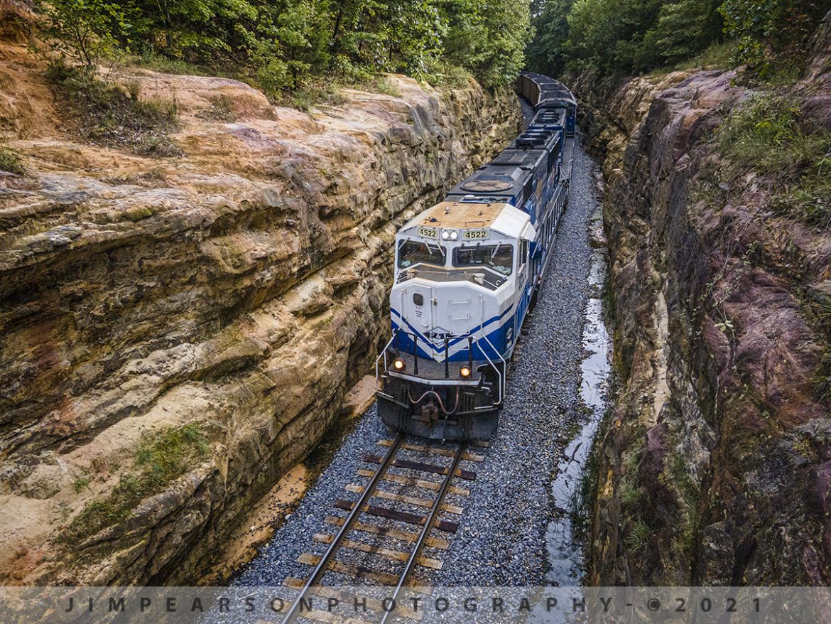
Northbound LG1 at Eastview Cut, Eastview, Kentucky
I spent this afternoon chasing the Paducah and Louisville Railway LG1 loaded coal train from Madisonville to Eastview, Kentucky. The latter was my goal for this chase as I’ve never photographed the cut at Eastview before and it’s been on my list for a while now.
I got to the location about 10 minutes before the train and checked out the scene with my Nikon first as the cut is right up against the bridge on Meeting Creek Road and I wasn’t sure I wanted or even needed to use the drone at this location. After consideration I decided to launch the drone as I felt it could give me the best platform for a shot that would offer the best perspective that was different from other photos I’ve seen taken from here.
With the drone in place, it was a short wait as I captured Paducah and Louisville University of Kentucky locomotives 4522 and 2012 lead the Louisville Gas & Electric loaded coal train as it made its way north and through the cut at Eastview, Kentucky.
Tech Info: Wide Photo: DJI Mavic Air 2 Drone, RAW, 4.5mm (24mm equivalent lens) f/2.8, 1/500, ISO 100, August 17, 2021.
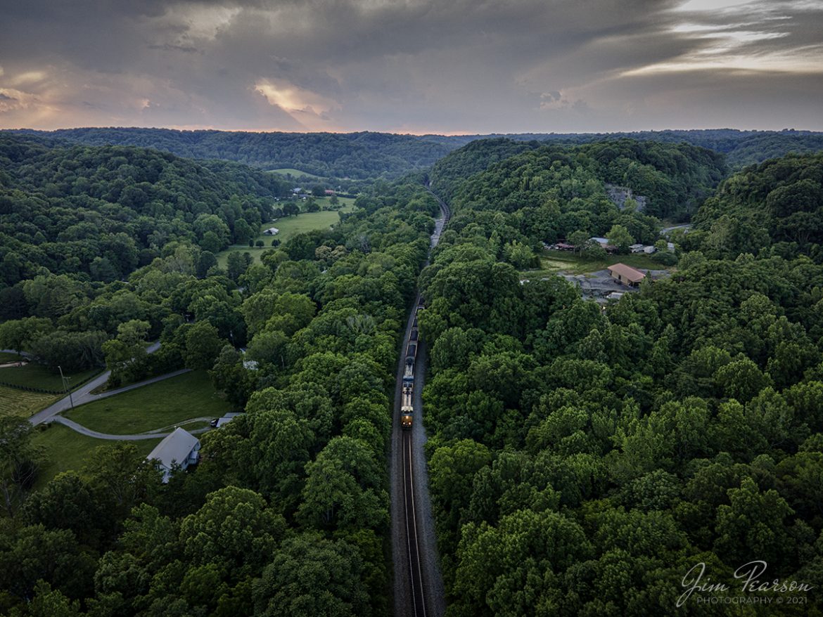
Southbound load of coal at dusk at Ridgetop, TN
CSX N302 heads south as it snakes its way through the valley as its tail end still exits Baker Tunnel back around the hills at Ridgetop, Tennessee on the Henderson Subdivision, as the light of day begins to fade from the scene. This trainset runs from Evansville, IN (EVWR) to Stilesboro, GA with a load of coal from the Sugar Camp Mine at Akin, IL and is headed to Georgia Power’s Bowen Plant to help keep the lights on!
Tech Info: Wide Photo: DJI Mavic Air 2 Drone, RAW, 4.5mm (24mm equivalent lens) f/2.8, 1/50, ISO 100, June 12, 2021.
![Paducah and Louisville Railway PRX1 at Calvert City, Kentucky
Paducah and Louisville Railway 3811, 4504 and 4516 lead loaded coal train PRX1 around the outer loop at the Calvert City Terminal in Calvert City, Kentucky on July 23, 2021, after picking up a load of coal for the TVA Shawnee Power Plant in West Paducah, KY.
According to Wikipedia: "The Paducah & Louisville Railway (reporting mark PAL) is a Class II railroad that operates freight service between Paducah and Louisville, Kentucky. The line is located entirely within the Commonwealth of Kentucky.
The 270-mile (430 km) line was purchased from Illinois Central Gulf Railroad in August 1986. The 223-mile (359 km) main route runs between Paducah and Louisville with branch lines from Paducah to Kevil and Mayfield, Kentucky, and another from Cecilia to Elizabethtown, Kentucky. The PAL interchanges with Burlington Northern Santa Fe (BNSF) and Canadian National (CN), formerly Illinois Central Railroad, in Paducah. In Madisonville, the line interchanges with CSX Transportation (CSXT).
In Louisville, the line interchanges with the Indiana Railroad (INRD), CSX Transportation (CSXT) and Norfolk Southern (NS). Class III line connections are at Princeton with the Fredonia Valley Railroad (FVRR) and at Louisville with the Louisville and Indiana Railroad (LIRC). The line today carries over 200,000 carloads of traffic on a CTC-controlled mainline with welded rail and even a section of multiple main tracks nearly 20 miles (32 km) long between Paducah and just east of Calvert City. This is a huge improvement from the little amount of traffic and poor condition the line was in by the time the ICG had sold it.
Today it is a big regional class II railroad connecting with four class I railroads (listed above), as well as the three shortline connections it makes which are also listed above. It has 270 route-miles of track, of which 233 miles (375 km) are its mainline running between its namesake towns of Paducah and Louisville, as well as branch lines to Mayfield, Kevil, and Elizabethtown. The railroad serves "many chemical plants and other manufacturing companies, several coal mines, numerous clay and stone quarries, lumber and propane distributors, farm [including a few large grain elevators] and mine equipment suppliers, warehouses, transloads, bulk terminals, riverports, and one military base."
The parent company of the PAL, P&L Transportation, also operates the Evansville Western Railway and the Appalachian and Ohio Railroad."
Tech Info: DJI Mavic Air 2 Drone, RAW, 4.5mm (24mm equivalent lens) f/2.8, 1/240, ISO 100.](http://www.jimpearsonphotography.com/wp-content/uploads/2021/08/WEB-07.23.21-PAL-PRX1-at-Calvert-City-KY-1170x878.jpg)
Paducah and Louisville Railway PRX1 at Calvert City, Kentucky
Paducah and Louisville Railway 3811, 4504 and 4516 lead loaded coal train PRX1 around the outer loop at the Calvert City Terminal in Calvert City, Kentucky on July 23, 2021, after picking up a load of coal for the TVA Shawnee Power Plant in West Paducah, KY.
According to Wikipedia: “The Paducah & Louisville Railway (reporting mark PAL) is a Class II railroad that operates freight service between Paducah and Louisville, Kentucky. The line is located entirely within the Commonwealth of Kentucky.
The 270-mile (430 km) line was purchased from Illinois Central Gulf Railroad in August 1986. The 223-mile (359 km) main route runs between Paducah and Louisville with branch lines from Paducah to Kevil and Mayfield, Kentucky, and another from Cecilia to Elizabethtown, Kentucky. The PAL interchanges with Burlington Northern Santa Fe (BNSF) and Canadian National (CN), formerly Illinois Central Railroad, in Paducah. In Madisonville, the line interchanges with CSX Transportation (CSXT).
In Louisville, the line interchanges with the Indiana Railroad (INRD), CSX Transportation (CSXT) and Norfolk Southern (NS). Class III line connections are at Princeton with the Fredonia Valley Railroad (FVRR) and at Louisville with the Louisville and Indiana Railroad (LIRC). The line today carries over 200,000 carloads of traffic on a CTC-controlled mainline with welded rail and even a section of multiple main tracks nearly 20 miles (32 km) long between Paducah and just east of Calvert City. This is a huge improvement from the little amount of traffic and poor condition the line was in by the time the ICG had sold it.
Today it is a big regional class II railroad connecting with four class I railroads (listed above), as well as the three shortline connections it makes which are also listed above. It has 270 route-miles of track, of which 233 miles (375 km) are its mainline running between its namesake towns of Paducah and Louisville, as well as branch lines to Mayfield, Kevil, and Elizabethtown. The railroad serves “many chemical plants and other manufacturing companies, several coal mines, numerous clay and stone quarries, lumber and propane distributors, farm [including a few large grain elevators] and mine equipment suppliers, warehouses, transloads, bulk terminals, riverports, and one military base.”
The parent company of the PAL, P&L Transportation, also operates the Evansville Western Railway and the Appalachian and Ohio Railroad.”
Tech Info: DJI Mavic Air 2 Drone, RAW, 4.5mm (24mm equivalent lens) f/2.8, 1/240, ISO 100.
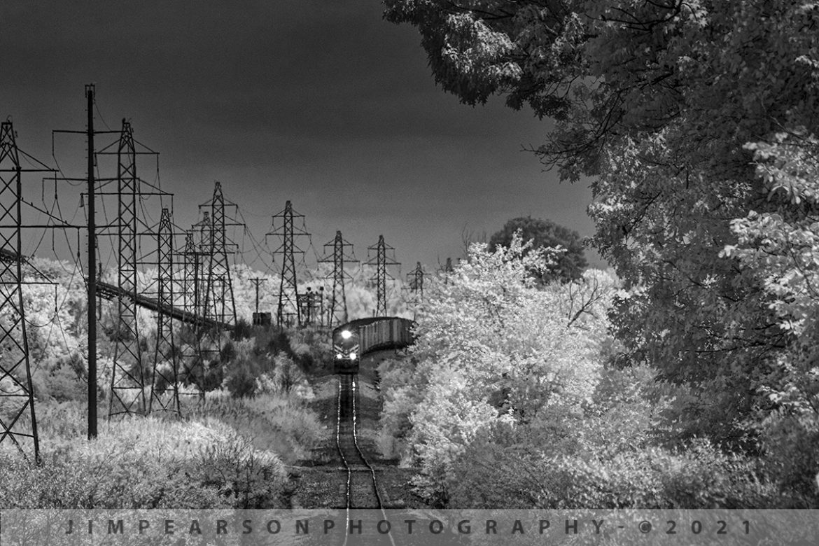
Paducah and Louisville PRX1 departs Warrior Coal at Nebo, KY
In this Infrared shot, Paducah and Louisville Railway 4516 leads a loaded coal train, and it begins its run from the Warrior Coal mine loop at Nebo, Ky on July 17th, 2021, on the Warrior Coal Mine lead. This load of coal is headed for Calvert City Terminal at Calvert City, KY.
Tech Info: Fuji XT-1, RAW, Converted to 720nm B&W IR, Sigma 150-600 @600mm, f/8, 1/500, ISO 800.
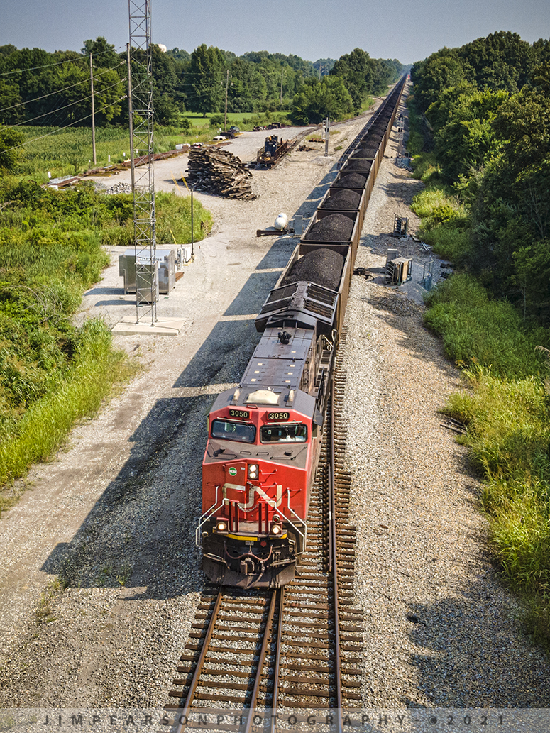
Southbound load of coal at Chiles Junction, West Paducah, KY
Canadian National 3050 leads a loaded coal train as it passes through Chiles Junction on its way south on the CN Bluford Subdivision at West Paducah, Kentucky on July 23rd, 2021.
Tech Info: DJI Mavic Air 2 Drone, RAW, 4.5mm (24mm equivalent lens) f/2.8, 1/500, ISO 100.
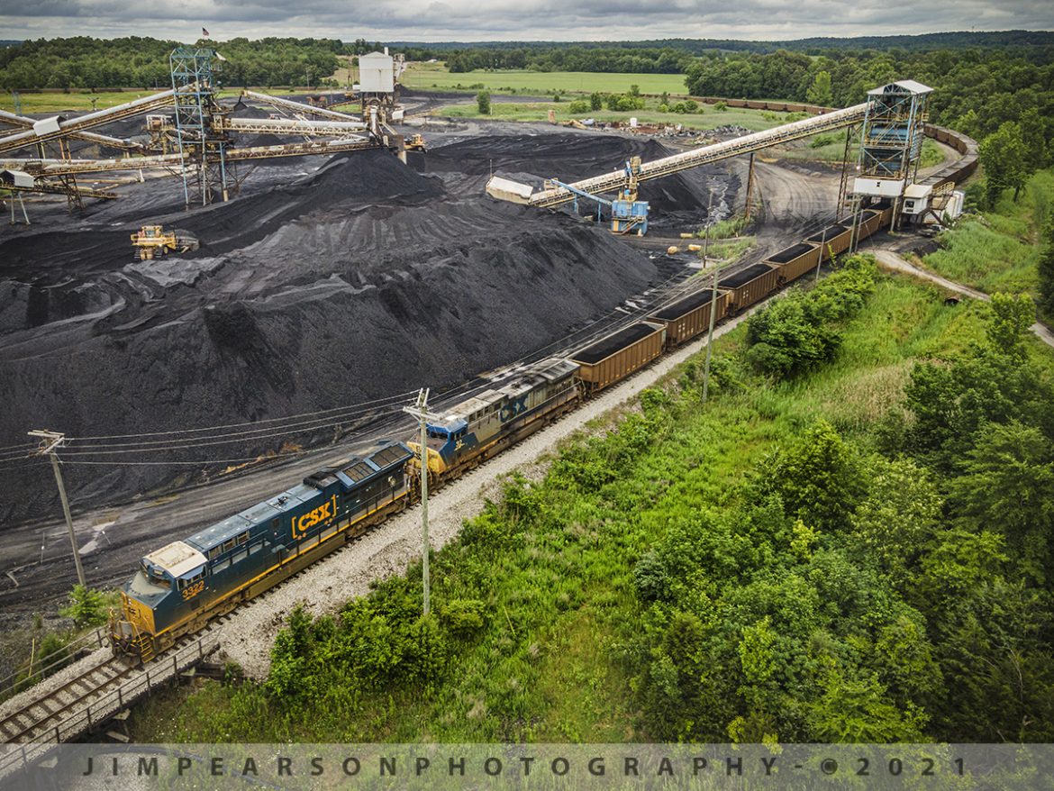
CSX J801-06 loads at Warrior Coal Mine Loop, Nebo, Kentucky
CSXT 3322 and 322 lead as CSX J801-06 creeps along as it starts to load at the Warrior Coal mine loop, just outside of Nebo, Kentucky on June 7th, 2021 under stormy skies. This train comes out of CSX Atkinson Yard in Madisonville, Ky where it will return to after loading and be combined with another loaded coal train of similar length before heading south on the Henderson Subdivision.
Tech Info: DJI Mavic Air 2 Drone, RAW, 4.5mm (24mm equivalent lens) f/2.8, 1/320, ISO 100.
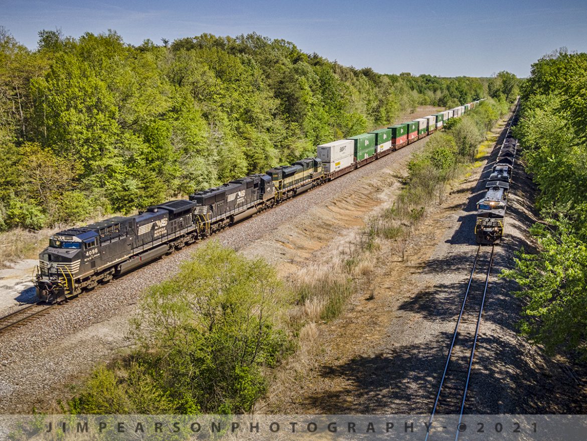
Norfolk Southern meet at Winslow, IN
A loaded Norfolk Southern Duke Energy coal train pulls west from the Charger mine at the HBD-DED Ayrshire just outside Winslow, Indiana as NS 224, a daily Louisville to St. Louis train, waits on the NS Southern East-West District main for it to clear Hatfield Junction on May 1st, 2021.
The lash-up on 224 is Norfolk Southern NS 4096 GE AC44C6M DC to AC Rebuilt (C40-9), NS 1844 EMD SD70ACU DC to AC Rebuilt (SD70), and NS 1068 EMD SD70ACe Erie Heritage Unit and runs daily from Louisville to St. Louis.
Tech Info: DJI Mavic Air 2 Drone, RAW, 4.5mm (24mm equivalent lens) f/2.8, 1/800, ISO 100.
CSX J801-06 travels the Warrior Coal Mine Loop, Nebo, Kentucky
CSXT 3322 and 322 lead as CSX J801-06 creeps along as it begins loading at the Warrior Coal mine loop, just outside of Nebo, Kentucky on June 7th, 2021 under stormy skies. This train comes out of CSX Atkinson Yard in Madisonville, Ky where it will return to after loading and be combined with another loaded coal train of similar length before heading south on the Henderson Subdivision.
Tech Info: DJI Mavic Air 2 Drone, RAW, 4.5mm (24mm equivalent lens) f/2.8, 1/320, ISO 100.