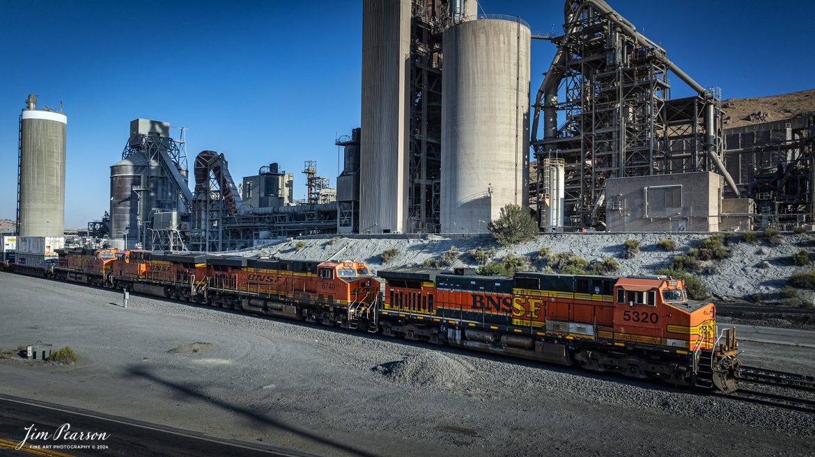
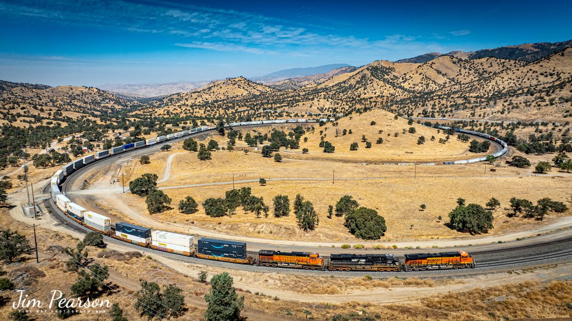
September 18th, 2024, BNSF 5320 leads a southbound freight past the cement plant in Tehachapi, California, on the Union Pacific Mojave Subdivision on a beautiful summer evening.
Tech Info: Nikon D810, RAW, Nikon 10-24 @ 12mm, f/5.6, 1/1250, ISO 100.
September 18th, 2024, BNSF 5320 leads a southbound freight past the cement plant in Tehachapi, California, on the Union Pacific Mojave Subdivision on a beautiful summer evening.
Tech Info: Nikon D810, RAW, Nikon 10-24 @ 12mm, f/5.6, 1/1250, ISO 100.
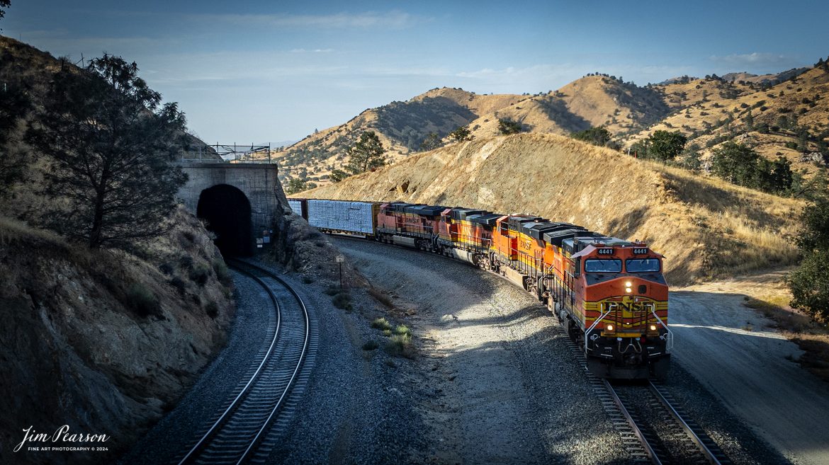
September 18th, 2024, BNSF 4441 leads an northbound freight train as they skirt around tunnel 10 from Tehachapi Loop on the Union Pacific Mojave Subdivision at, Woodford, California.
According to Wikipedia: The Tehachapi Loop is a 3,779-foot-long (0.72 mi; 1.15 km) spiral, or helix, on the Union Pacific Railroad Mojave Subdivision through Tehachapi Pass, of the Tehachapi Mountains in Kern County, south-central California. The line connects Bakersfield and the San Joaquin Valley to Mojave in the Mojave Desert.
Rising at a steady two-percent grade, the track gains 77 feet (23 m) in elevation and makes a 1,210-foot-diameter (370 m) circle. Any train that is more than 3,800 feet (1,200 m) long—about 56 boxcars—passes over itself going around the loop. At the bottom of the loop, the track passes through Tunnel 9, the ninth tunnel built as the railroad was extended from Bakersfield.
The line averages about 36 freight trains each day. Passenger trains such as Amtrak’s San Joaquin are banned from the loop, although the Coast Starlight can use it as a detour. Its frequent trains and scenic setting make the Tehachapi Loop popular with railfans. In 1998, it was named a National Historic Civil Engineering Landmark. It is also designated as California Historical Landmark #508.
One of the engineering feats of its day, the Loop was built by Southern Pacific Railroad to ease the grade over Tehachapi Pass. Construction began in 1874, and the line opened in 1876.
Tech Info: DJI Mavic 3 Classic Drone, RAW, 24mm, f/2.8, 1/1600, ISO 290.

Analog Wednesday – I’ve recently added a like new Mamiya C330 Professional 2 ¼ square film camera to my camera bag and on Wednesday’s I’ll be sharing images I’ve shot with it. This shot is from September 19th, 2024, of two Westbound intermodals racing each other as they head out of Mojave, CA toward Bakersfield, CA through the Tehachapi Pass.
Tech Info: Mamiya C330 Professional, Ilford HP5 Film, Mamiya 80mm, f/4, 1/250, ISO 400.

Analog Wednesday – I’ve recently added a like new Mamiya C330 Professional 2 ¼ square film camera to my camera bag and on Wednesday’s I’ll be sharing images I’ve shot with it. This shot is from September 24th, 2024, of a Westbound BNSF intermodal as it starts its downhill run from the summit in Cajon Pass, CA.
Tech Info: Mamiya C330 Professional, Ilford HP5 Film, Mamiya 80mm, f/4, 1/400, ISO 400.
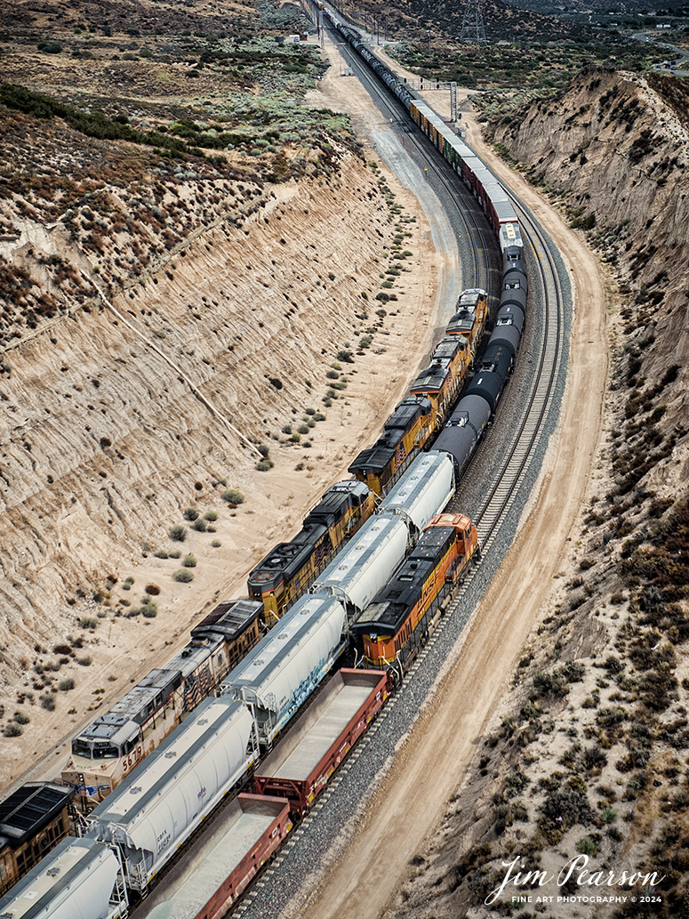
September 20th, 2024, Today I had the good fortune of catching a three way meet between a Union Pacific Freight, a BNSF freight and a BNSF rock train at the Summit of Cajon Pass in southern California and the BNSF Cajon Subdivision as Hwy 138 and the tracks head into stormy weather.
According to Wikipedia: Cajon Pass is a mountain pass between the San Bernardino Mountains to the east and the San Gabriel Mountains to the west in Southern California. Created by the movements of the San Andreas Fault, it has an elevation of 3,777 ft (1,151 m). Located in the Mojave Desert, the pass is an important link from the Greater San Bernardino Area to the Victor Valley, and northeast to Las Vegas. The Cajon Pass area is on the Pacific Crest Trail.
Cajon Pass is at the head of Horsethief Canyon, traversed by California State Route 138 (SR 138) and railroad tracks owned by BNSF Railway and Union Pacific Railroad. Improvements in 1972 reduced the railroad’s maximum elevation from about 3,829 to 3,777 feet while reducing curvature. Interstate 15 does not traverse Cajon Pass, but rather the nearby Cajon Summit. The entire area, Cajon Pass and Cajon Summit, is often referred to as Cajon Pass, but a distinction is made between Cajon Pass and Cajon Summit.
The California Southern Railroad, a subsidiary of the Atchison, Topeka and Santa Fe Railway, was the first railroad through Cajon Pass. The line through the pass was built in the early 1880s to connect the present-day cities of Barstow and San Diego. Today the Union Pacific Railroad and BNSF Railway (the successor to the Santa Fe) use the pass to reach Los Angeles and San Bernardino as part of the Southern Transcon. Due to the many trains, scenery and easy access, it is a popular location for railfans, and many photographs of trains on Cajon Pass appear in books and magazines.
The Union Pacific Railroad owns one track through the pass, on the previous Southern Pacific Railroad Palmdale cutoff, opened in 1967. The BNSF Railway owns two tracks and began to operate a third main track in the summer of 2008. The railroads share track rights through the pass ever since the Union Pacific gained track rights on the Santa Fe portion negotiated under the original Los Angeles and Salt Lake Railroad.
Tech Info: DJI Mavic 3 Classic Drone, RAW, 24mm, f/2.8, 1/1250, ISO 100.
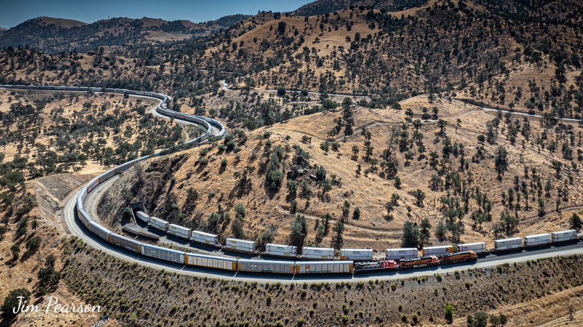
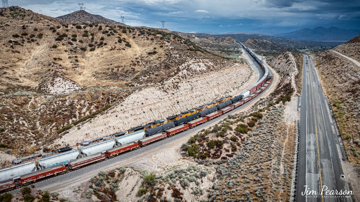
September 18th, 2024, BNSF 7115, 9128 and Ferromex 4050 lead an westbound train next to tunnel 10, as they wait for an eastbound intermodal to clear Tehachapi Loop on the Union Pacific Mojave Subdivision at Keene, California.
According to Wikipedia: The Tehachapi Loop is a 3,779-foot-long (0.72 mi; 1.15 km) spiral, or helix, on the Union Pacific Railroad Mojave Subdivision through Tehachapi Pass, of the Tehachapi Mountains in Kern County, south-central California. The line connects Bakersfield and the San Joaquin Valley to Mojave in the Mojave Desert.
Rising at a steady two-percent grade, the track gains 77 feet (23 m) in elevation and makes a 1,210-foot-diameter (370 m) circle. Any train that is more than 3,800 feet (1,200 m) long—about 56 boxcars—passes over itself going around the loop. At the bottom of the loop, the track passes through Tunnel 9, the ninth tunnel built as the railroad was extended from Bakersfield.
The line averages about 36 freight trains each day. Passenger trains such as Amtrak’s San Joaquin are banned from the loop, although the Coast Starlight can use it as a detour. Its frequent trains and scenic setting make the Tehachapi Loop popular with railfans. In 1998, it was named a National Historic Civil Engineering Landmark. It is also designated as California Historical Landmark #508.
One of the engineering feats of its day, the Loop was built by Southern Pacific Railroad to ease the grade over Tehachapi Pass. Construction began in 1874, and the line opened in 1876.
Tech Info: DJI Mavic 3 Classic Drone, RAW, 24mm, f/2.8, 1/2500, ISO 100.
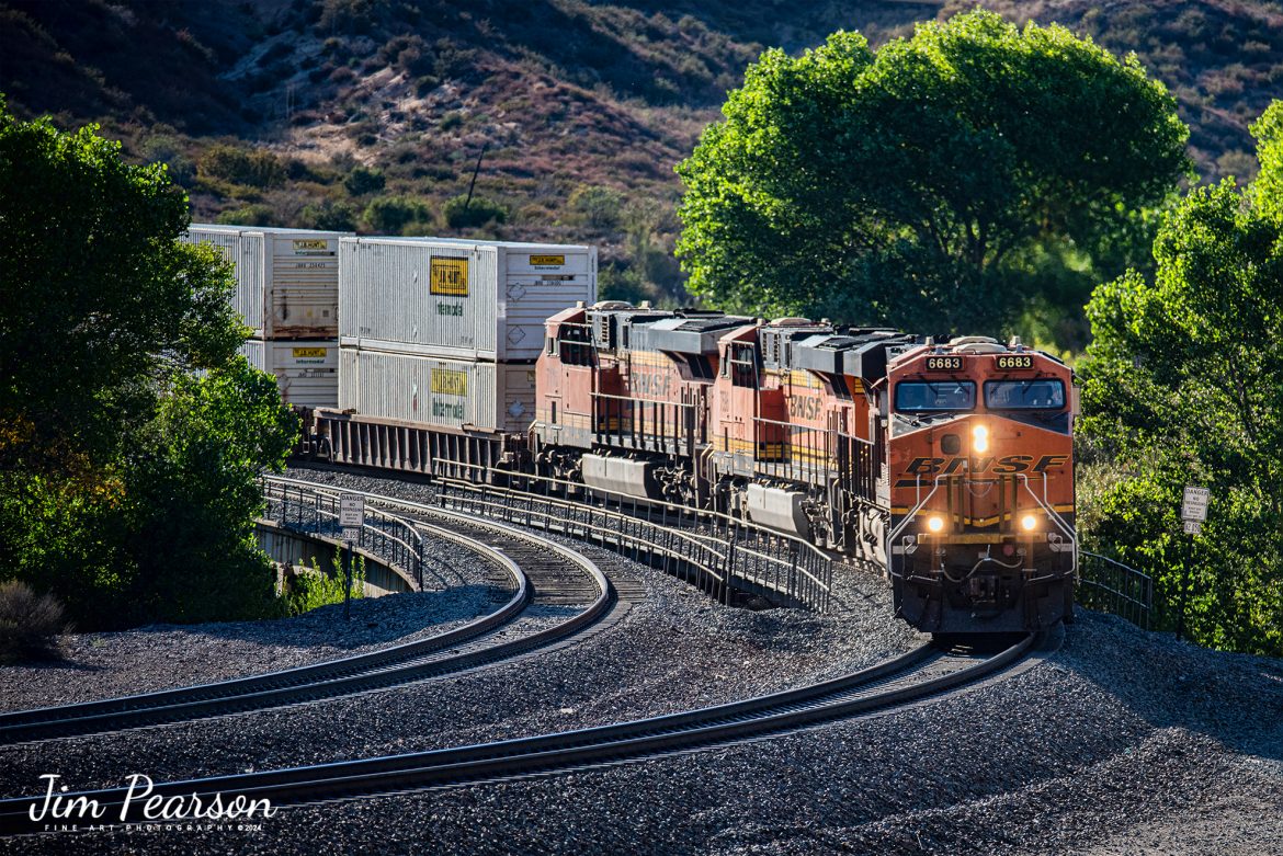
BNSF 6683 leads an westbound intermodal as it rounds a curve coming down hill in the Cajon Pass at Cajon, California on the BNSF Cajon Subdivision, on September 24th, 2024.
According to Wikipedia: Cajon Pass is a mountain pass between the San Bernardino Mountains to the east and the San Gabriel Mountains to the west in Southern California. Created by the movements of the San Andreas Fault, it has an elevation of 3,777 ft (1,151 m). Located in the Mojave Desert, the pass is an important link from the Greater San Bernardino Area to the Victor Valley, and northeast to Las Vegas. The Cajon Pass area is on the Pacific Crest Trail.
Cajon Pass is at the head of Horsethief Canyon, traversed by California State Route 138 (SR 138) and railroad tracks owned by BNSF Railway and Union Pacific Railroad. Improvements in 1972 reduced the railroad’s maximum elevation from about 3,829 to 3,777 feet while reducing curvature. Interstate 15 does not traverse Cajon Pass, but rather the nearby Cajon Summit. The entire area, Cajon Pass and Cajon Summit, is often referred to as Cajon Pass, but a distinction is made between Cajon Pass and Cajon Summit.
The California Southern Railroad, a subsidiary of the Atchison, Topeka and Santa Fe Railway, was the first railroad through Cajon Pass. The line through the pass was built in the early 1880s to connect the present-day cities of Barstow and San Diego. Today the Union Pacific Railroad and BNSF Railway (the successor to the Santa Fe) use the pass to reach Los Angeles and San Bernardino as part of the Southern Transcon. Due to the many trains, scenery and easy access, it is a popular location for railfans, and many photographs of trains on Cajon Pass appear in books and magazines.
The Union Pacific Railroad owns one track through the pass, on the previous Southern Pacific Railroad Palmdale cutoff, opened in 1967. The BNSF Railway owns two tracks and began to operate a third main track in the summer of 2008. The railroads share track rights through the pass ever since the Union Pacific gained track rights on the Santa Fe portion negotiated under the original Los Angeles and Salt Lake Railroad.
Tech Info: Nikon D810, RAW, Nikon 70-300 @ 220mm, f/5.6, 1/800, ISO 280.
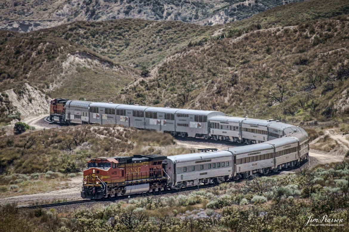
June 6, 2006 – BNSF 4419 leads a business train east bound through the Cajon Pass in southern California, headed to Barstow, CA.
According to Wikipedia: Cajon Pass is a mountain pass between the San Bernardino Mountains to the east and the San Gabriel Mountains to the west in Southern California. Created by the movements of the San Andreas Fault, it has an elevation of 3,777 ft (1,151 m). Located in the Mojave Desert, the pass is an important link from the Greater San Bernardino Area to the Victor Valley, and northeast to Las Vegas. The Cajon Pass area is on the Pacific Crest Trail.
Cajon Pass is at the head of Horsethief Canyon, traversed by California State Route 138 (SR 138) and railroad tracks owned by BNSF Railway and Union Pacific Railroad. Improvements in 1972 reduced the railroad’s maximum elevation from about 3,829 to 3,777 feet while reducing curvature. Interstate 15 does not traverse Cajon Pass, but rather the nearby Cajon Summit. The entire area, Cajon Pass and Cajon Summit, is often referred to as Cajon Pass, but a distinction is made between Cajon Pass and Cajon Summit.
The California Southern Railroad, a subsidiary of the Atchison, Topeka and Santa Fe Railway, was the first railroad through Cajon Pass. The line through the pass was built in the early 1880s to connect the present-day cities of Barstow and San Diego. Today the Union Pacific Railroad and BNSF Railway (the successor to the Santa Fe) use the pass to reach Los Angeles and San Bernardino as part of the Southern Transcon. Due to the many trains, scenery and easy access, it is a popular location for railfans, and many photographs of trains on Cajon Pass appear in books and magazines.
Tech Info: Nikon D200, RAW, Nikon 70-300 @ 200mm, f/6.3, 1/400, ISO 100.
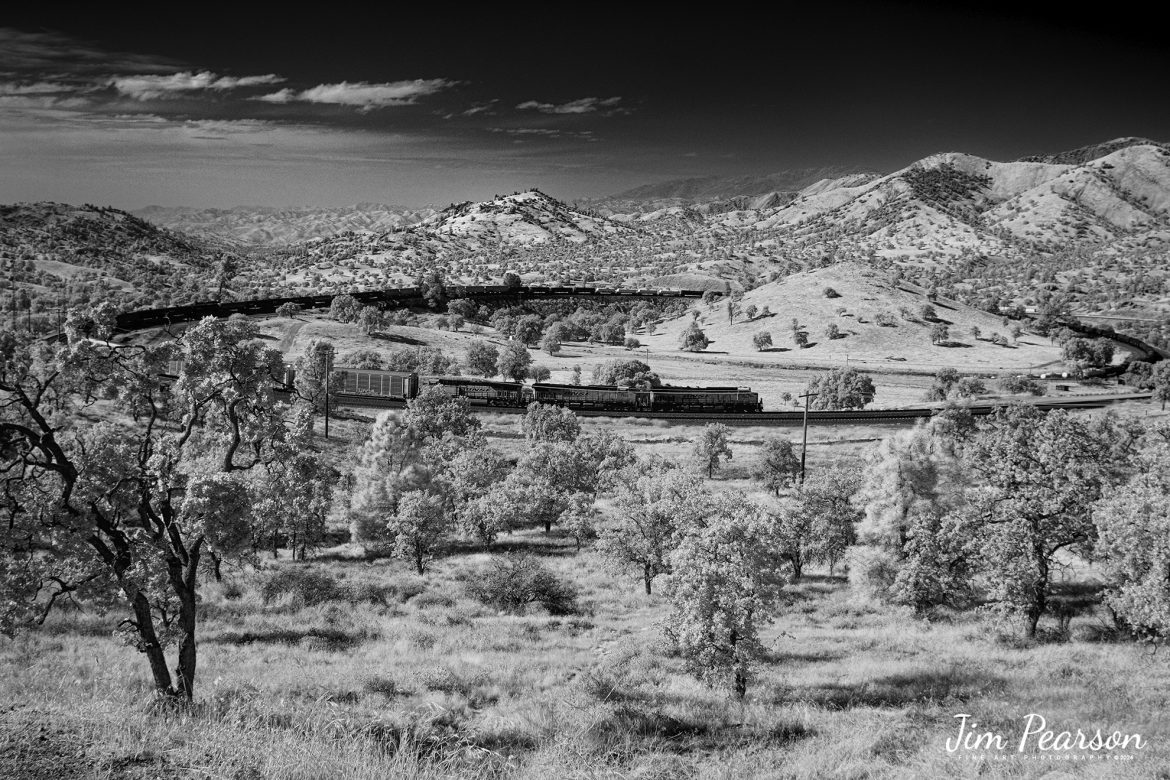
In this Saturday’s Infrared photo I caught BNSF 7904, 7853 and 2167 leading an eastbound train through the famous Tehachapi Loop on the Union Pacific Mojave Subdivision at Keene, California, on September 18th, 2024.
According to Wikipedia: The Tehachapi Loop is a 3,779-foot-long (0.72 mi; 1.15 km) spiral, or helix, on the Union Pacific Railroad Mojave Subdivision through Tehachapi Pass, of the Tehachapi Mountains in Kern County, south-central California. The line connects Bakersfield and the San Joaquin Valley to Mojave in the Mojave Desert.
Rising at a steady two-percent grade, the track gains 77 feet (23 m) in elevation and makes a 1,210-foot-diameter (370 m) circle. Any train that is more than 3,800 feet (1,200 m) long—about 56 boxcars—passes over itself going around the loop. At the bottom of the loop, the track passes through Tunnel 9, the ninth tunnel built as the railroad was extended from Bakersfield.
The line averages about 36 freight trains each day. Passenger trains such as Amtrak’s San Joaquin are banned from the loop, although the Coast Starlight can use it as a detour. Its frequent trains and scenic setting make the Tehachapi Loop popular with railfans. In 1998, it was named a National Historic Civil Engineering Landmark. It is also designated as California Historical Landmark #508.
One of the engineering feats of its day, the Loop was built by Southern Pacific Railroad to ease the grade over Tehachapi Pass. Construction began in 1874, and the line opened in 1876.
Tech Info: Fuji XT1 converted to Infrared, RAW, Nikon 24-70, @24mm, f/4, 1/1000, ISO 100.
September 20th, 2024, Today I had the good fortune of catching a three way meet between a Union Pacific Freight, a BNSF freight and a BNSF rock train at the Summit of Cajon Pass in southern California and the BNSF Cajon Subdivision as Hwy 138 and the tracks head into stormy weather.
According to Wikipedia: Cajon Pass is a mountain pass between the San Bernardino Mountains to the east and the San Gabriel Mountains to the west in Southern California. Created by the movements of the San Andreas Fault, it has an elevation of 3,777 ft (1,151 m). Located in the Mojave Desert, the pass is an important link from the Greater San Bernardino Area to the Victor Valley, and northeast to Las Vegas. The Cajon Pass area is on the Pacific Crest Trail.
Cajon Pass is at the head of Horsethief Canyon, traversed by California State Route 138 (SR 138) and railroad tracks owned by BNSF Railway and Union Pacific Railroad. Improvements in 1972 reduced the railroad’s maximum elevation from about 3,829 to 3,777 feet while reducing curvature. Interstate 15 does not traverse Cajon Pass, but rather the nearby Cajon Summit. The entire area, Cajon Pass and Cajon Summit, is often referred to as Cajon Pass, but a distinction is made between Cajon Pass and Cajon Summit.
The California Southern Railroad, a subsidiary of the Atchison, Topeka and Santa Fe Railway, was the first railroad through Cajon Pass. The line through the pass was built in the early 1880s to connect the present-day cities of Barstow and San Diego. Today the Union Pacific Railroad and BNSF Railway (the successor to the Santa Fe) use the pass to reach Los Angeles and San Bernardino as part of the Southern Transcon. Due to the many trains, scenery and easy access, it is a popular location for railfans, and many photographs of trains on Cajon Pass appear in books and magazines.
The Union Pacific Railroad owns one track through the pass, on the previous Southern Pacific Railroad Palmdale cutoff, opened in 1967. The BNSF Railway owns two tracks and began to operate a third main track in the summer of 2008. The railroads share track rights through the pass ever since the Union Pacific gained track rights on the Santa Fe portion negotiated under the original Los Angeles and Salt Lake Railroad.
Tech Info: DJI Mavic 3 Classic Drone, RAW, 24mm, f/2.8, 1/1250, ISO 100.
September 18th, 2024, BNSF 8057, NS 8068 and BNSF 5177 lead an eastbound train through the famous Tehachapi Loop on the Union Pacific Mojave Subdivision at Keene, California.
I’m thankful that I had and brought my drone on this trip as access to trackside at the loop has been cut off! I was last here 7 years ago and then you could get to where you could shoot trackside, but now there’s viewing platform about ¾ mile away. Being able to fly the drone allowed me many spectacular views that I’ve never been able to get in the past.
According to Wikipedia: The Tehachapi Loop is a 3,779-foot-long (0.72 mi; 1.15 km) spiral, or helix, on the Union Pacific Railroad Mojave Subdivision through Tehachapi Pass, of the Tehachapi Mountains in Kern County, south-central California. The line connects Bakersfield and the San Joaquin Valley to Mojave in the Mojave Desert.
Rising at a steady two-percent grade, the track gains 77 feet (23 m) in elevation and makes a 1,210-foot-diameter (370 m) circle. Any train that is more than 3,800 feet (1,200 m) long—about 56 boxcars—passes over itself going around the loop. At the bottom of the loop, the track passes through Tunnel 9, the ninth tunnel built as the railroad was extended from Bakersfield.
The line averages about 36 freight trains each day. Passenger trains such as Amtrak’s San Joaquin are banned from the loop, although the Coast Starlight can use it as a detour. ts frequent trains and scenic setting make the Tehachapi Loop popular with railfans. In 1998, it was named a National Historic Civil Engineering Landmark. It is also designated as California Historical Landmark #508.
One of the engineering feats of its day, the Loop was built by Southern Pacific Railroad to ease the grade over Tehachapi Pass. Construction began in 1874, and the line opened in 1876.
Tech Info: DJI Mavic 3 Classic Drone, RAW, 24mm, f/2.8, 1/2500, ISO 100.
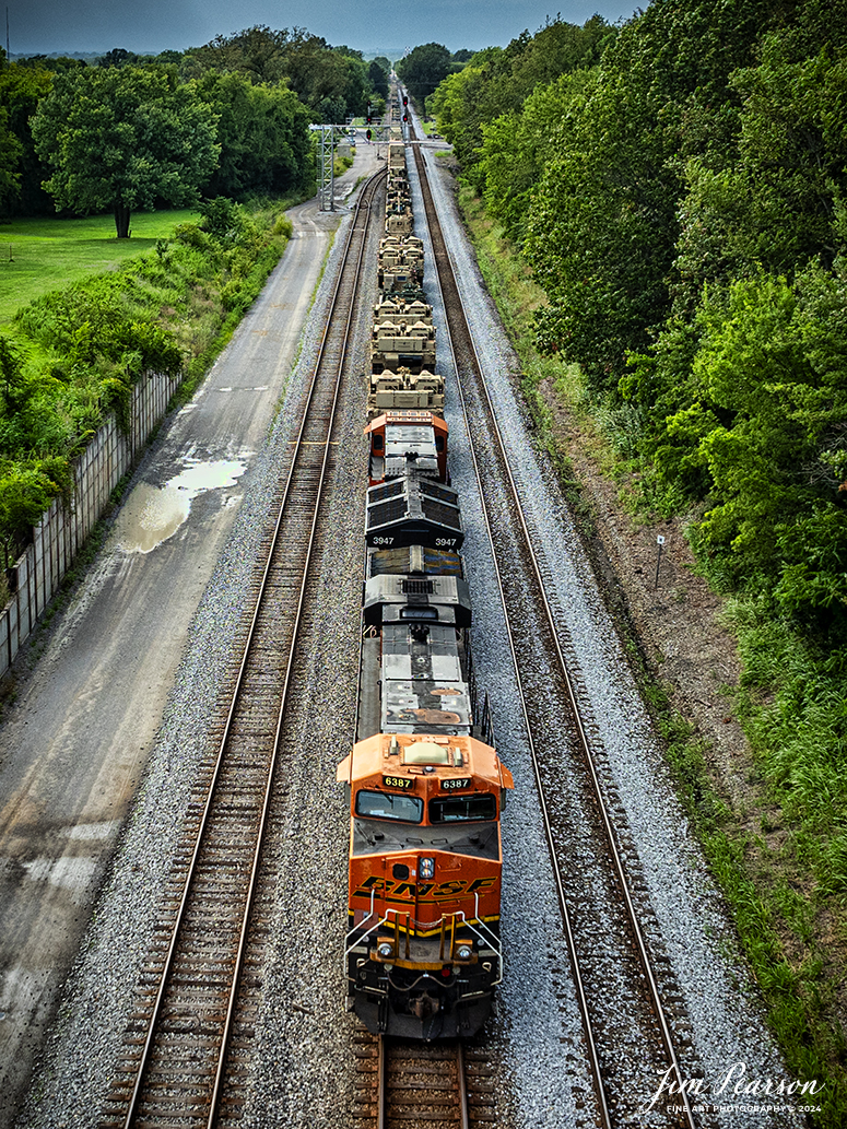
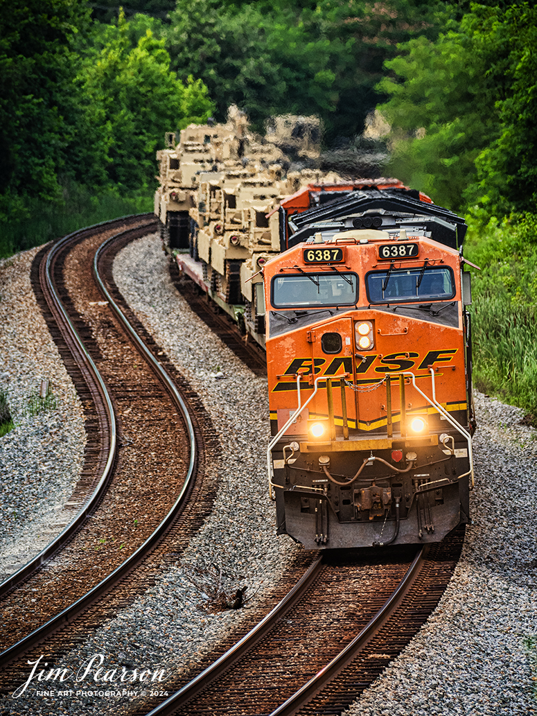
BNSF 6387 and 3947 lead CSX S577 as the crew backs a loaded military train onto the Ft. Campbell lead at from Casky yard at Hopkinsville, Ky, on the CSX Henderson Subdivision on July 9th, 2024.
Tech Info: DJI Mavic 3 Classic Drone, RAW, 22mm, f/2.8, 1/1000, ISO 140.
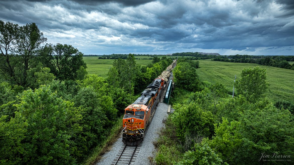
BNSF 6387 and 3947 lead CSX S577 as the crew backs a loaded military train onto the Ft. Campbell lead at Hopkinsville, Ky, from the CSX Henderson Subdivision on July 9th, 2024, under threatening skies during a Tornado Warning spawned by the remnants of Hurricane Alberto. Fellow railfan Brian Caswell and I sat for a couple hours hoping that Ft. Campbell would show up to carry the equipment onto the base, but unfortunately it didn’t happen. Despite the warnings here very little rain fell and most of the tornados spawned in our area were more to the northeast up in Indiana.
Tech Info: DJI Mavic 3 Classic Drone, RAW, 22mm, f/2.8, 1/1000, ISO 210.

May 5th, 2004 – Blast from The Past – A conductor performs a roll-by inspection at the siding at Freeze, in Cape Girardeau, Missouri on the BNSF River Subdivision.
From what I find online the subdivision runs between St. Louis, MO and Memphis, TN and is an ex-Frisco line that hugs the west bank of the Mississippi River for about 100 miles or so.
This image from a trip I did over 20 years ago with a group of good friends from the Western Kentucky Chapter of the National Railway Historical Society and for one reason or another this, along with many other images from the trip were never processed. So, expect to see other images from this trip in the weeks to come on Saturdays! Thankfully the D100 had an option for doing voice recordings tied to the images where I gave locations and other information. Otherwise, the captions would have a lot less information.
Tech Info: Nikon D100, Nikon 24mm, f/13, 1/500, ISO 500.
BNSF 6387 and 3947 lead CSX S577 as the crew backs a loaded military train onto the Ft. Campbell lead at from Casky yard at Hopkinsville, Ky, on the CSX Henderson Subdivision on July 9th, 2024.
Tech Info: DJI Mavic 3 Classic Drone, RAW, 22mm, f/2.8, 1/2500, ISO 160.
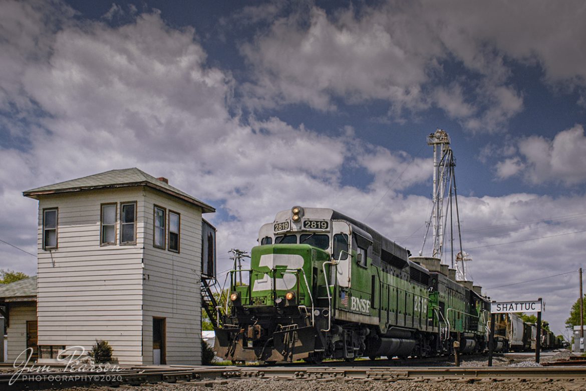
May 1, 2005 – Blast From The Past – BNSF 2819 heads past the old interlocking tower at Shattuc, Illinois on BNSF’s Beardstown Subdivision as it crosses over the Illinois Subdivision.
From what I gather from the web, CSX closed the Illinois Subdivision through here at one point and used it for car storage, but then I find references to the line being used now by The Prairie Line, a shortline out of O’Fallon, IL (I’m now told the shortline hasn’t materialized yet). BNSF still owns and uses the Bardstown Sub. I’m also told that the diamond was removed in 2019, at least temporarily.
In the past this tower controlled the movements of trains on the Chicago, Burlington, and Quincy railroad along with the B&O Railroad. It was closed sometime in the 1980’s and from what I can find on the web it was torn down in late 2014. I’ve also found reports where it was bought by a collector and moved. Whichever is correct, this picture isn’t to be replicated again today since the tower is now gone.
If you’d like to read a great piece on the tower, check out this article on The Trackside Photographer by Tom Gatermann, who visited the tower the same year as me.
http://thetracksidephotographer.com/tag/shattuc-tower/
Photograph the towers when and where you can as they continue to disappear from the railroad landscape.
Tech Info: Nikon D100, Sigma 24-70mm @ 24mm, f/8, 1/800, ISO 400.
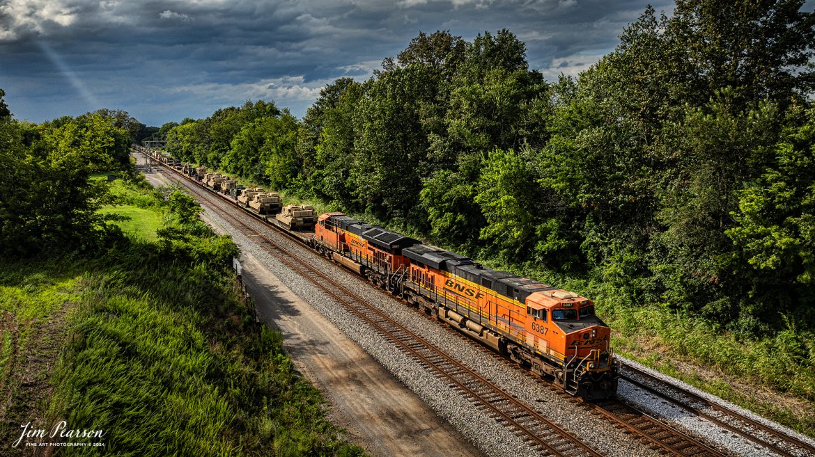
BNSF 6387 and 3947 lead CSX S577 heads south as it passes through the S Curve at Nortonville, Kentucky with a loaded military train bound for Ft. Campbell on the CSX Henderson Subdivision on July 9th, 2024
Tech Info: Nikon D810, Sigma 150-600mm @280mm, RAW, 22mm, f/5.6, 1/800, ISO 400.

BNSF 6387 and 3947 lead CSX S577 as the crew backs a loaded military train onto the Ft. Campbell lead at Hopkinsville, Ky, from the CSX Henderson Subdivision on July 9th, 2024, under threatening skies during a Tornado Warning spawned by the remnants of Hurricane Alberto. Fellow railfan Brian Caswell and I sat for a couple hours hoping that Ft. Campbell would show up to carry the equipment onto the base, but unfortunately it didn’t happen. Despite the warnings here very little rain fell and most of the tornados spawned in our area were more to the northeast up in Indiana.
Tech Info: DJI Mavic 3 Classic Drone, RAW, 22mm, f/2.8, 1/1000, ISO 200.

BNSF 6387 and 3947 lead CSX S577 heads south across Gum Lick Trestle, just north of Kelly, Kentucky with a loaded military train bound for Ft. Campbell on the CSX Henderson Subdivision on July 9th, 2024
Tech Info: DJI Mavic 3 Classic Drone, RAW, 22mm, f/2.8, 1/2000, ISO 110.

BNSF 6387 and 3947 lead CSX S577 up the viaduct at Rahm, Indiana where they will cross the Ohio River into Henderson, Kentucky with a loaded military train bound for Ft. Campbell on the CSX Henderson Subdivision on July 9th, 2024
Tech Info: DJI Mavic 3 Classic Drone, RAW, 22mm, f/2.8, 1/1600, ISO 140.

BNSF 6387 and 3947 lead CSX S577 across the Ohio River at Henderson, Kentucky with a loaded military train bound for Ft. Campbell on the CSX Henderson Subdivision on July 9th, 2024
Tech Info: DJI Mavic 3 Classic Drone, RAW, 22mm, f/2.8, 1/1600, ISO 190.