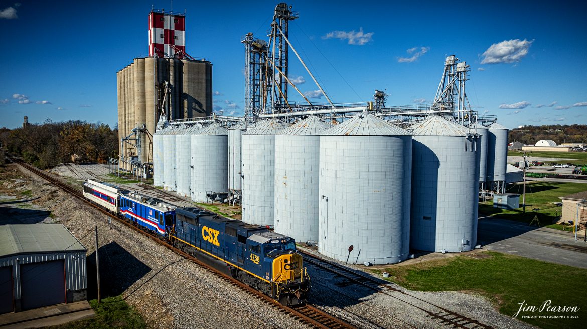
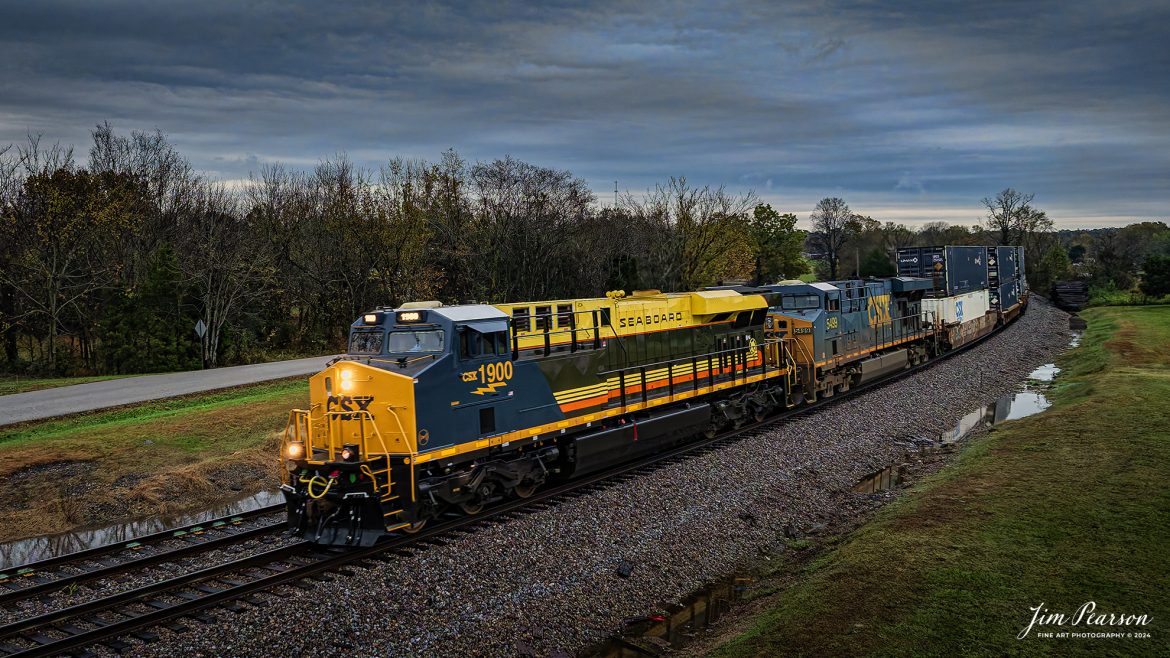
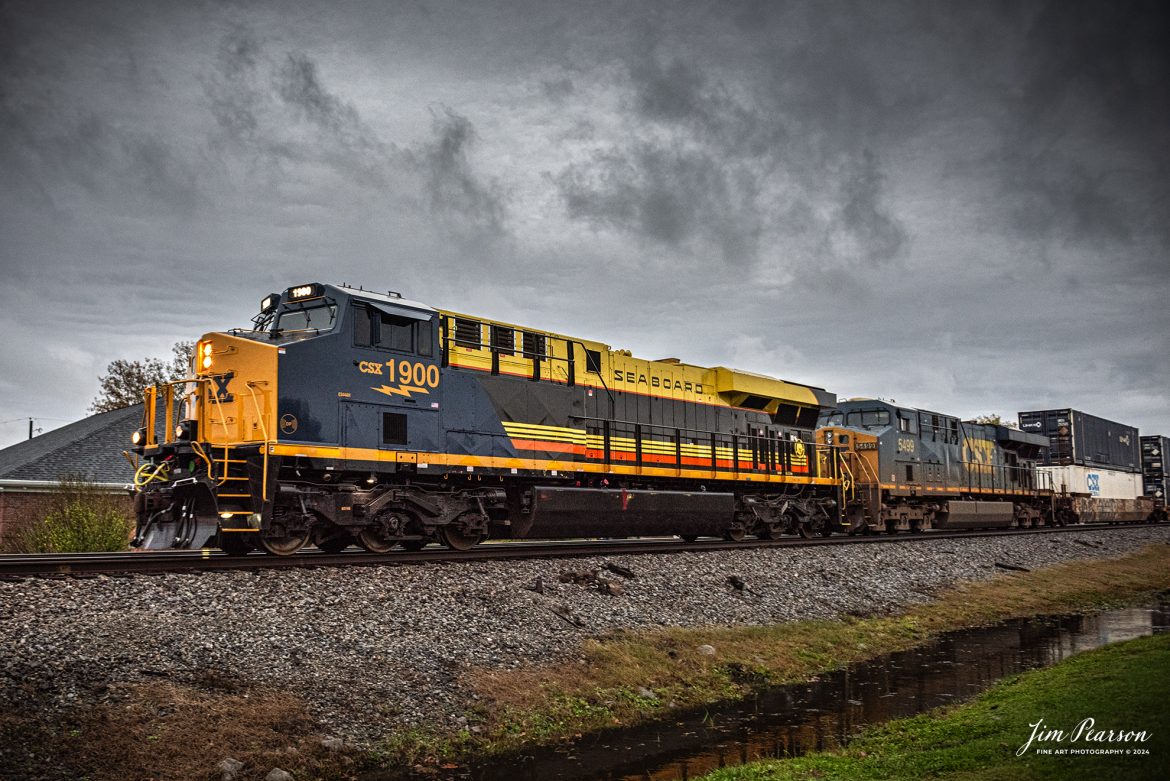
September 18th, 2024, BNSF 4441 leads an northbound  freight train as they skirt around tunnel 10 from Tehachapi Loop on the Union Pacific Mojave Subdivision at, Woodford, California.

According to Wikipedia: The Tehachapi Loop is a 3,779-foot-long (0.72 mi; 1.15 km) spiral, or helix, on the Union Pacific Railroad Mojave Subdivision through Tehachapi Pass, of the Tehachapi Mountains in Kern County, south-central California. The line connects Bakersfield and the San Joaquin Valley to Mojave in the Mojave Desert.

Rising at a steady two-percent grade, the track gains 77 feet (23 m) in elevation and makes a 1,210-foot-diameter (370 m) circle. Any train that is more than 3,800 feet (1,200 m) long—about 56 boxcars—passes over itself going around the loop. At the bottom of the loop, the track passes through Tunnel 9, the ninth tunnel built as the railroad was extended from Bakersfield.

The line averages about 36 freight trains each day. Passenger trains such as Amtrak's San Joaquin are banned from the loop, although the Coast Starlight can use it as a detour. Its frequent trains and scenic setting make the Tehachapi Loop popular with railfans. In 1998, it was named a National Historic Civil Engineering Landmark. It is also designated as California Historical Landmark #508.

One of the engineering feats of its day, the Loop was built by Southern Pacific Railroad to ease the grade over Tehachapi Pass. Construction began in 1874, and the line opened in 1876.

Tech Info: DJI Mavic 3 Classic Drone, RAW, 24mm, f/2.8, 1/1600, ISO 290.

#railroad #railroads #train, #trains #railway #railway #steamtrains #railtransport #railroadengines #picturesoftrains #picturesofrailways #besttrainphotograph #bestphoto #photographyoftrains #bestsoldpicture #JimPearsonPhotography #trainsfromtheair #trainsfromadrone

BNSF 4441 leads an northbound freight train as they skirt around tunnel 10 from Tehachapi Loop…

September 18th, 2024, BNSF 4441 leads an northbound freight train as they skirt around tunnel 10 from Tehachapi Loop on the Union Pacific Mojave Subdivision at, Woodford, California.

According to Wikipedia: The Tehachapi Loop is a 3,779-foot-long (0.72 mi; 1.15 km) spiral, or helix, on the Union Pacific Railroad Mojave Subdivision through Tehachapi Pass, of the Tehachapi Mountains in Kern County, south-central California. The line connects Bakersfield and the San Joaquin Valley to Mojave in the Mojave Desert.

Rising at a steady two-percent grade, the track gains 77 feet (23 m) in elevation and makes a 1,210-foot-diameter (370 m) circle. Any train that is more than 3,800 feet (1,200 m) long—about 56 boxcars—passes over itself going around the loop. At the bottom of the loop, the track passes through Tunnel 9, the ninth tunnel built as the railroad was extended from Bakersfield.

The line averages about 36 freight trains each day. Passenger trains such as Amtrak’s San Joaquin are banned from the loop, although the Coast Starlight can use it as a detour. Its frequent trains and scenic setting make the Tehachapi Loop popular with railfans. In 1998, it was named a National Historic Civil Engineering Landmark. It is also designated as California Historical Landmark #508.

One of the engineering feats of its day, the Loop was built by Southern Pacific Railroad to ease the grade over Tehachapi Pass. Construction began in 1874, and the line opened in 1876.

Tech Info: DJI Mavic 3 Classic Drone, RAW, 24mm, f/2.8, 1/1600, ISO 290.

September 18th, 2024, A BNSF northbound train works its way out of the horseshoe curve on the Union Pacific Mojave Subdivision at Caliente, California, starting their climb up through the Tehachapi Pass.

According to Wikipedia: Established in the 1870s, Caliente was originally named Allens Camp for a cattle rancher and settler named Gabriel Allen. Later, the name Agua Caliente, coming from hot springs in the area, was proposed and may have been used. This name conflicted with the community of the same name in Sonoma County. With the railroad's arrival in 1875, the shortened name Caliente was adopted.

Caliente prospered during Southern Pacific Railroad's construction of Tehachapi Pass line. For a time, the Telegraph Stage Line and the Cerro Gordo Freighting Co. also ran through Caliente and its full-time population grew to 200. There were approximately 60 buildings, including 20 or more saloons.

Tech Info: DJI Mavic 3 Classic Drone, RAW, 24mm, f/2.8, 1/1600, ISO 100.

#railroad #railroads #train, #trains #railway #railway #steamtrains #railtransport #railroadengines #picturesoftrains #picturesofrailways #besttrainphotograph #bestphoto #photographyoftrains #bestsoldpicture #JimPearsonPhotography #trainsfromtheair #trainsfromadrone

A BNSF northbound train works its way on the Union Pacific Mojave Subdivision at Caliente, California

September 18th, 2024, A BNSF northbound train works its way out of the horseshoe curve on the Union Pacific Mojave Subdivision at Caliente, California, starting their climb up through the Tehachapi Pass.

According to Wikipedia: Established in the 1870s, Caliente was originally named Allens Camp for a cattle rancher and settler named Gabriel Allen. Later, the name Agua Caliente, coming from hot springs in the area, was proposed and may have been used. This name conflicted with the community of the same name in Sonoma County. With the railroad’s arrival in 1875, the shortened name Caliente was adopted.

Caliente prospered during Southern Pacific Railroad’s construction of Tehachapi Pass line. For a time, the Telegraph Stage Line and the Cerro Gordo Freighting Co. also ran through Caliente and its full-time population grew to 200. There were approximately 60 buildings, including 20 or more saloons.

Tech Info: DJI Mavic 3 Classic Drone, RAW, 24mm, f/2.8, 1/1600, ISO 100.

September 20th, 2024, Today I had the good fortune of catching a three way meet between a Union Pacific Freight, a BNSF freight and a BNSF rock train at the Summit of Cajon Pass in southern California and the BNSF Cajon Subdivision as Hwy 138 and the tracks head into stormy weather.

According to Wikipedia: Cajon Pass is a mountain pass between the San Bernardino Mountains to the east and the San Gabriel Mountains to the west in Southern California. Created by the movements of the San Andreas Fault, it has an elevation of 3,777 ft (1,151 m). Located in the Mojave Desert, the pass is an important link from the Greater San Bernardino Area to the Victor Valley, and northeast to Las Vegas. The Cajon Pass area is on the Pacific Crest Trail.

Cajon Pass is at the head of Horsethief Canyon, traversed by California State Route 138 (SR 138) and railroad tracks owned by BNSF Railway and Union Pacific Railroad. Improvements in 1972 reduced the railroad's maximum elevation from about 3,829 to 3,777 feet while reducing curvature. Interstate 15 does not traverse Cajon Pass, but rather the nearby Cajon Summit. The entire area, Cajon Pass and Cajon Summit, is often referred to as Cajon Pass, but a distinction is made between Cajon Pass and Cajon Summit.

The California Southern Railroad, a subsidiary of the Atchison, Topeka and Santa Fe Railway, was the first railroad through Cajon Pass. The line through the pass was built in the early 1880s to connect the present-day cities of Barstow and San Diego. Today the Union Pacific Railroad and BNSF Railway (the successor to the Santa Fe) use the pass to reach Los Angeles and San Bernardino as part of the Southern Transcon. Due to the many trains, scenery and easy access, it is a popular location for railfans, and many photographs of trains on Cajon Pass appear in books and magazines.

The Union Pacific Railroad owns one track through the pass, on the previous Southern Pacific Railroad Palmdale cutoff, opened in 1967. The BNSF Railway owns two tracks and began to operate a third main track in the summer of 2008. The railroads share track rights through the pass ever since the Union Pacific gained track rights on the Santa Fe portion negotiated under the original Los Angeles and Salt Lake Railroad. 

Tech Info: DJI Mavic 3 Classic Drone, RAW, 24mm, f/2.8, 1/1250, ISO 100.

#railroad #railroads #train, #trains #railway #railway #steamtrains #railtransport #railroadengines #picturesoftrains #picturesofrailways #besttrainphotograph #bestphoto #photographyoftrains #bestsoldpicture #JimPearsonPhotography #trainsfromtheair #trainsfromadrone #CajonPass

Three way meet between a Union Pacific Freight, a BNSF freight and a BNSF rock train at the Summit of Cajon Pass

September 20th, 2024, Today I had the good fortune of catching a three way meet between a Union Pacific Freight, a BNSF freight and a BNSF rock train at the Summit of Cajon Pass in southern California and the BNSF Cajon Subdivision as Hwy 138 and the tracks head into stormy weather.

According to Wikipedia: Cajon Pass is a mountain pass between the San Bernardino Mountains to the east and the San Gabriel Mountains to the west in Southern California. Created by the movements of the San Andreas Fault, it has an elevation of 3,777 ft (1,151 m). Located in the Mojave Desert, the pass is an important link from the Greater San Bernardino Area to the Victor Valley, and northeast to Las Vegas. The Cajon Pass area is on the Pacific Crest Trail.

Cajon Pass is at the head of Horsethief Canyon, traversed by California State Route 138 (SR 138) and railroad tracks owned by BNSF Railway and Union Pacific Railroad. Improvements in 1972 reduced the railroad’s maximum elevation from about 3,829 to 3,777 feet while reducing curvature. Interstate 15 does not traverse Cajon Pass, but rather the nearby Cajon Summit. The entire area, Cajon Pass and Cajon Summit, is often referred to as Cajon Pass, but a distinction is made between Cajon Pass and Cajon Summit.

The California Southern Railroad, a subsidiary of the Atchison, Topeka and Santa Fe Railway, was the first railroad through Cajon Pass. The line through the pass was built in the early 1880s to connect the present-day cities of Barstow and San Diego. Today the Union Pacific Railroad and BNSF Railway (the successor to the Santa Fe) use the pass to reach Los Angeles and San Bernardino as part of the Southern Transcon. Due to the many trains, scenery and easy access, it is a popular location for railfans, and many photographs of trains on Cajon Pass appear in books and magazines.

The Union Pacific Railroad owns one track through the pass, on the previous Southern Pacific Railroad Palmdale cutoff, opened in 1967. The BNSF Railway owns two tracks and began to operate a third main track in the summer of 2008. The railroads share track rights through the pass ever since the Union Pacific gained track rights on the Santa Fe portion negotiated under the original Los Angeles and Salt Lake Railroad.

Tech Info: DJI Mavic 3 Classic Drone, RAW, 24mm, f/2.8, 1/1250, ISO 100.

BNSF 4037, 4549, CP 8125 and BNSF 5733 lead an eastbound intermodal at Phelan, CA, as they cross the dry wash east of Hwy 138 in the Cajon Pass on September 20th, 2024, on the BNSF Cajon Subdivision.   

According to Wikipedia: Cajon Pass is a mountain pass between the San Bernardino Mountains to the east and the San Gabriel Mountains to the west in Southern California. Created by the movements of the San Andreas Fault, it has an elevation of 3,777 ft (1,151 m). Located in the Mojave Desert, the pass is an important link from the Greater San Bernardino Area to the Victor Valley, and northeast to Las Vegas. The Cajon Pass area is on the Pacific Crest Trail.

Cajon Pass is at the head of Horsethief Canyon, traversed by California State Route 138 (SR 138) and railroad tracks owned by BNSF Railway and Union Pacific Railroad. Improvements in 1972 reduced the railroad's maximum elevation from about 3,829 to 3,777 feet while reducing curvature. Interstate 15 does not traverse Cajon Pass, but rather the nearby Cajon Summit. The entire area, Cajon Pass and Cajon Summit, is often referred to as Cajon Pass, but a distinction is made between Cajon Pass and Cajon Summit.

The California Southern Railroad, a subsidiary of the Atchison, Topeka and Santa Fe Railway, was the first railroad through Cajon Pass. The line through the pass was built in the early 1880s to connect the present-day cities of Barstow and San Diego. Today the Union Pacific Railroad and BNSF Railway (the successor to the Santa Fe) use the pass to reach Los Angeles and San Bernardino as part of the Southern Transcon. Due to the many trains, scenery and easy access, it is a popular location for railfans, and many photographs of trains on Cajon Pass appear in books and magazines.

The Union Pacific Railroad owns one track through the pass, on the previous Southern Pacific Railroad Palmdale cutoff, opened in 1967. The BNSF Railway owns two tracks and began to operate a third main track in the summer of 2008. The railroads share track rights through the pass ever since the Union Pacific gained track rights on the Santa Fe portion negotiated under the original Los Angeles and Salt Lake Railroad. 

Tech Info: DJI Mavic 3 Classic Drone, RAW, 24mm, f/2.8, 1/4000, ISO 140.

#railroad #railroads #train, #trains #railway #railway #steamtrains #railtransport #railroadengines #picturesoftrains #picturesofrailways #besttrainphotograph #bestphoto #photographyoftrains #bestsoldpicture #JimPearsonPhotography #trainsfromtheair #trainsfromadrone #CajonPass

BNSF 4037, 4549, CP 8125 and BNSF 5733 lead an eastbound intermodal at Phelan, CA

BNSF 4037, 4549, CP 8125 and BNSF 5733 lead an eastbound intermodal at Phelan, CA, as they cross the dry wash east of Hwy 138 in the Cajon Pass on September 20th, 2024, on the BNSF Cajon Subdivision.

According to Wikipedia: Cajon Pass is a mountain pass between the San Bernardino Mountains to the east and the San Gabriel Mountains to the west in Southern California. Created by the movements of the San Andreas Fault, it has an elevation of 3,777 ft (1,151 m). Located in the Mojave Desert, the pass is an important link from the Greater San Bernardino Area to the Victor Valley, and northeast to Las Vegas. The Cajon Pass area is on the Pacific Crest Trail.

Cajon Pass is at the head of Horsethief Canyon, traversed by California State Route 138 (SR 138) and railroad tracks owned by BNSF Railway and Union Pacific Railroad. Improvements in 1972 reduced the railroad’s maximum elevation from about 3,829 to 3,777 feet while reducing curvature. Interstate 15 does not traverse Cajon Pass, but rather the nearby Cajon Summit. The entire area, Cajon Pass and Cajon Summit, is often referred to as Cajon Pass, but a distinction is made between Cajon Pass and Cajon Summit.

The California Southern Railroad, a subsidiary of the Atchison, Topeka and Santa Fe Railway, was the first railroad through Cajon Pass. The line through the pass was built in the early 1880s to connect the present-day cities of Barstow and San Diego. Today the Union Pacific Railroad and BNSF Railway (the successor to the Santa Fe) use the pass to reach Los Angeles and San Bernardino as part of the Southern Transcon. Due to the many trains, scenery and easy access, it is a popular location for railfans, and many photographs of trains on Cajon Pass appear in books and magazines.

The Union Pacific Railroad owns one track through the pass, on the previous Southern Pacific Railroad Palmdale cutoff, opened in 1967. The BNSF Railway owns two tracks and began to operate a third main track in the summer of 2008. The railroads share track rights through the pass ever since the Union Pacific gained track rights on the Santa Fe portion negotiated under the original Los Angeles and Salt Lake Railroad.

Tech Info: DJI Mavic 3 Classic Drone, RAW, 24mm, f/2.8, 1/4000, ISO 140.

September 18th, 2024, BNSF 7115, 9128 and Ferromex 4050 lead an westbound train next to tunnel 10, as they wait for an eastbound intermodal to clear Tehachapi Loop on the Union Pacific Mojave Subdivision at Keene, California.

According to Wikipedia: The Tehachapi Loop is a 3,779-foot-long (0.72 mi; 1.15 km) spiral, or helix, on the Union Pacific Railroad Mojave Subdivision through Tehachapi Pass, of the Tehachapi Mountains in Kern County, south-central California. The line connects Bakersfield and the San Joaquin Valley to Mojave in the Mojave Desert.

Rising at a steady two-percent grade, the track gains 77 feet (23 m) in elevation and makes a 1,210-foot-diameter (370 m) circle. Any train that is more than 3,800 feet (1,200 m) long—about 56 boxcars—passes over itself going around the loop. At the bottom of the loop, the track passes through Tunnel 9, the ninth tunnel built as the railroad was extended from Bakersfield.

The line averages about 36 freight trains each day. Passenger trains such as Amtrak's San Joaquin are banned from the loop, although the Coast Starlight can use it as a detour. Its frequent trains and scenic setting make the Tehachapi Loop popular with railfans. In 1998, it was named a National Historic Civil Engineering Landmark. It is also designated as California Historical Landmark #508.

One of the engineering feats of its day, the Loop was built by Southern Pacific Railroad to ease the grade over Tehachapi Pass. Construction began in 1874, and the line opened in 1876.

Tech Info: DJI Mavic 3 Classic Drone, RAW, 24mm, f/2.8, 1/2500, ISO 100.

#railroad #railroads #train, #trains #railway #railway #steamtrains #railtransport #railroadengines #picturesoftrains #picturesofrailways #besttrainphotograph #bestphoto #photographyoftrains #bestsoldpicture #JimPearsonPhotography #trainsfromtheair #trainsfromadrone #TehachapiLoop

BNSF 7115, 9128 and Ferromex 4050 lead an westbound train next to tunnel 10…

September 18th, 2024, BNSF 7115, 9128 and Ferromex 4050 lead an westbound train next to tunnel 10, as they wait for an eastbound intermodal to clear Tehachapi Loop on the Union Pacific Mojave Subdivision at Keene, California.

According to Wikipedia: The Tehachapi Loop is a 3,779-foot-long (0.72 mi; 1.15 km) spiral, or helix, on the Union Pacific Railroad Mojave Subdivision through Tehachapi Pass, of the Tehachapi Mountains in Kern County, south-central California. The line connects Bakersfield and the San Joaquin Valley to Mojave in the Mojave Desert.

Rising at a steady two-percent grade, the track gains 77 feet (23 m) in elevation and makes a 1,210-foot-diameter (370 m) circle. Any train that is more than 3,800 feet (1,200 m) long—about 56 boxcars—passes over itself going around the loop. At the bottom of the loop, the track passes through Tunnel 9, the ninth tunnel built as the railroad was extended from Bakersfield.

The line averages about 36 freight trains each day. Passenger trains such as Amtrak’s San Joaquin are banned from the loop, although the Coast Starlight can use it as a detour. Its frequent trains and scenic setting make the Tehachapi Loop popular with railfans. In 1998, it was named a National Historic Civil Engineering Landmark. It is also designated as California Historical Landmark #508.

One of the engineering feats of its day, the Loop was built by Southern Pacific Railroad to ease the grade over Tehachapi Pass. Construction began in 1874, and the line opened in 1876.

Tech Info: DJI Mavic 3 Classic Drone, RAW, 24mm, f/2.8, 1/2500, ISO 100.

A Union Pacific freight makes its way west down the Cajon Pass as it approaches the Mormon Rocks area in Cajon Pass, California on September 20th, 2024.

According to Wikipedia: Cajon Pass is a mountain pass between the San Bernardino Mountains to the east and the San Gabriel Mountains to the west in Southern California. Created by the movements of the San Andreas Fault, it has an elevation of 3,777 ft (1,151 m). Located in the Mojave Desert, the pass is an important link from the Greater San Bernardino Area to the Victor Valley, and northeast to Las Vegas. The Cajon Pass area is on the Pacific Crest Trail.

Cajon Pass is at the head of Horsethief Canyon, traversed by California State Route 138 (SR 138) and railroad tracks owned by BNSF Railway and Union Pacific Railroad. Improvements in 1972 reduced the railroad's maximum elevation from about 3,829 to 3,777 feet while reducing curvature. Interstate 15 does not traverse Cajon Pass, but rather the nearby Cajon Summit. The entire area, Cajon Pass and Cajon Summit, is often referred to as Cajon Pass, but a distinction is made between Cajon Pass and Cajon Summit.

The California Southern Railroad, a subsidiary of the Atchison, Topeka and Santa Fe Railway, was the first railroad through Cajon Pass. The line through the pass was built in the early 1880s to connect the present-day cities of Barstow and San Diego. Today the Union Pacific Railroad and BNSF Railway (the successor to the Santa Fe) use the pass to reach Los Angeles and San Bernardino as part of the Southern Transcon. Due to the many trains, scenery and easy access, it is a popular location for railfans, and many photographs of trains on Cajon Pass appear in books and magazines.

The Union Pacific Railroad owns one track through the pass, on the previous Southern Pacific Railroad Palmdale cutoff, opened in 1967. The BNSF Railway owns two tracks and began to operate a third main track in the summer of 2008. The railroads share track rights through the pass ever since the Union Pacific gained track rights on the Santa Fe portion negotiated under the original Los Angeles and Salt Lake Railroad. 

Tech Info: DJI Mavic 3 Classic Drone, RAW, 24mm, f/2.8, 1/2000, ISO 100.

#railroad #railroads #train, #trains #railway #railway #steamtrains #railtransport #railroadengines #picturesoftrains #picturesofrailways #besttrainphotograph #bestphoto #photographyoftrains #bestsoldpicture #JimPearsonPhotography #trainsfromtheair #trainsfromadrone #CajonPass

A Union Pacific freight heads west down the Cajon Pass as it approaches the Mormon Rocks area in Cajon Pass, CA

A Union Pacific freight makes its way west down the Cajon Pass as it approaches the Mormon Rocks area in Cajon Pass, California on September 20th, 2024.

According to Wikipedia: Cajon Pass is a mountain pass between the San Bernardino Mountains to the east and the San Gabriel Mountains to the west in Southern California. Created by the movements of the San Andreas Fault, it has an elevation of 3,777 ft (1,151 m). Located in the Mojave Desert, the pass is an important link from the Greater San Bernardino Area to the Victor Valley, and northeast to Las Vegas. The Cajon Pass area is on the Pacific Crest Trail.

Cajon Pass is at the head of Horsethief Canyon, traversed by California State Route 138 (SR 138) and railroad tracks owned by BNSF Railway and Union Pacific Railroad. Improvements in 1972 reduced the railroad’s maximum elevation from about 3,829 to 3,777 feet while reducing curvature. Interstate 15 does not traverse Cajon Pass, but rather the nearby Cajon Summit. The entire area, Cajon Pass and Cajon Summit, is often referred to as Cajon Pass, but a distinction is made between Cajon Pass and Cajon Summit.

The California Southern Railroad, a subsidiary of the Atchison, Topeka and Santa Fe Railway, was the first railroad through Cajon Pass. The line through the pass was built in the early 1880s to connect the present-day cities of Barstow and San Diego. Today the Union Pacific Railroad and BNSF Railway (the successor to the Santa Fe) use the pass to reach Los Angeles and San Bernardino as part of the Southern Transcon. Due to the many trains, scenery and easy access, it is a popular location for railfans, and many photographs of trains on Cajon Pass appear in books and magazines.

The Union Pacific Railroad owns one track through the pass, on the previous Southern Pacific Railroad Palmdale cutoff, opened in 1967. The BNSF Railway owns two tracks and began to operate a third main track in the summer of 2008. The railroads share track rights through the pass ever since the Union Pacific gained track rights on the Santa Fe portion negotiated under the original Los Angeles and Salt Lake Railroad.

Tech Info: DJI Mavic 3 Classic Drone, RAW, 24mm, f/2.8, 1/2000, ISO 100.

September 20th, 2024, Today I had the good fortune of catching a three way meet between a Union Pacific Freight, a BNSF freight and a BNSF rock train at the Summit of Cajon Pass in southern California and the BNSF Cajon Subdivision as Hwy 138 and the tracks head into stormy weather.

According to Wikipedia: Cajon Pass is a mountain pass between the San Bernardino Mountains to the east and the San Gabriel Mountains to the west in Southern California. Created by the movements of the San Andreas Fault, it has an elevation of 3,777 ft (1,151 m). Located in the Mojave Desert, the pass is an important link from the Greater San Bernardino Area to the Victor Valley, and northeast to Las Vegas. The Cajon Pass area is on the Pacific Crest Trail.

Cajon Pass is at the head of Horsethief Canyon, traversed by California State Route 138 (SR 138) and railroad tracks owned by BNSF Railway and Union Pacific Railroad. Improvements in 1972 reduced the railroad's maximum elevation from about 3,829 to 3,777 feet while reducing curvature. Interstate 15 does not traverse Cajon Pass, but rather the nearby Cajon Summit. The entire area, Cajon Pass and Cajon Summit, is often referred to as Cajon Pass, but a distinction is made between Cajon Pass and Cajon Summit.

The California Southern Railroad, a subsidiary of the Atchison, Topeka and Santa Fe Railway, was the first railroad through Cajon Pass. The line through the pass was built in the early 1880s to connect the present-day cities of Barstow and San Diego. Today the Union Pacific Railroad and BNSF Railway (the successor to the Santa Fe) use the pass to reach Los Angeles and San Bernardino as part of the Southern Transcon. Due to the many trains, scenery and easy access, it is a popular location for railfans, and many photographs of trains on Cajon Pass appear in books and magazines.

The Union Pacific Railroad owns one track through the pass, on the previous Southern Pacific Railroad Palmdale cutoff, opened in 1967. The BNSF Railway owns two tracks and began to operate a third main track in the summer of 2008. The railroads share track rights through the pass ever since the Union Pacific gained track rights on the Santa Fe portion negotiated under the original Los Angeles and Salt Lake Railroad. 

Tech Info: DJI Mavic 3 Classic Drone, RAW, 24mm, f/2.8, 1/1250, ISO 100.

#railroad #railroads #train, #trains #railway #railway #steamtrains #railtransport #railroadengines #picturesoftrains #picturesofrailways #besttrainphotograph #bestphoto #photographyoftrains #bestsoldpicture #JimPearsonPhotography #trainsfromtheair #trainsfromadrone #CajonPass

September 20th, 2024, Today I had the good fortune of catching a three way meet at the Summit of Cajon Pass, CA

September 20th, 2024, Today I had the good fortune of catching a three way meet between a Union Pacific Freight, a BNSF freight and a BNSF rock train at the Summit of Cajon Pass in southern California and the BNSF Cajon Subdivision as Hwy 138 and the tracks head into stormy weather.

According to Wikipedia: Cajon Pass is a mountain pass between the San Bernardino Mountains to the east and the San Gabriel Mountains to the west in Southern California. Created by the movements of the San Andreas Fault, it has an elevation of 3,777 ft (1,151 m). Located in the Mojave Desert, the pass is an important link from the Greater San Bernardino Area to the Victor Valley, and northeast to Las Vegas. The Cajon Pass area is on the Pacific Crest Trail.

Cajon Pass is at the head of Horsethief Canyon, traversed by California State Route 138 (SR 138) and railroad tracks owned by BNSF Railway and Union Pacific Railroad. Improvements in 1972 reduced the railroad’s maximum elevation from about 3,829 to 3,777 feet while reducing curvature. Interstate 15 does not traverse Cajon Pass, but rather the nearby Cajon Summit. The entire area, Cajon Pass and Cajon Summit, is often referred to as Cajon Pass, but a distinction is made between Cajon Pass and Cajon Summit.

The California Southern Railroad, a subsidiary of the Atchison, Topeka and Santa Fe Railway, was the first railroad through Cajon Pass. The line through the pass was built in the early 1880s to connect the present-day cities of Barstow and San Diego. Today the Union Pacific Railroad and BNSF Railway (the successor to the Santa Fe) use the pass to reach Los Angeles and San Bernardino as part of the Southern Transcon. Due to the many trains, scenery and easy access, it is a popular location for railfans, and many photographs of trains on Cajon Pass appear in books and magazines.

The Union Pacific Railroad owns one track through the pass, on the previous Southern Pacific Railroad Palmdale cutoff, opened in 1967. The BNSF Railway owns two tracks and began to operate a third main track in the summer of 2008. The railroads share track rights through the pass ever since the Union Pacific gained track rights on the Santa Fe portion negotiated under the original Los Angeles and Salt Lake Railroad.

Tech Info: DJI Mavic 3 Classic Drone, RAW, 24mm, f/2.8, 1/1250, ISO 100.

September 18th, 2024, Union Pacific 5533 leads an westbound intermodal train as they exit tunnel 10 at Tehachapi Loop on the Union Pacific Mojave Subdivision at Keene, California.

I’m thankful that I had and brought my drone on this trip as access to trackside at the loop has been cut off! I was last here 7 years ago and then you could get to where you could shoot trackside, but now there’s viewing platform about ¾ mile away. Being able to fly the drone allowed me many spectacular views that I’ve never been able to get in the past.

According to Wikipedia: The Tehachapi Loop is a 3,779-foot-long (0.72 mi; 1.15 km) spiral, or helix, on the Union Pacific Railroad Mojave Subdivision through Tehachapi Pass, of the Tehachapi Mountains in Kern County, south-central California. The line connects Bakersfield and the San Joaquin Valley to Mojave in the Mojave Desert.

Rising at a steady two-percent grade, the track gains 77 feet (23 m) in elevation and makes a 1,210-foot-diameter (370 m) circle. Any train that is more than 3,800 feet (1,200 m) long—about 56 boxcars—passes over itself going around the loop. At the bottom of the loop, the track passes through Tunnel 9, the ninth tunnel built as the railroad was extended from Bakersfield.

The line averages about 36 freight trains each day. Passenger trains such as Amtrak's San Joaquin are banned from the loop, although the Coast Starlight can use it as a detour. Its frequent trains and scenic setting make the Tehachapi Loop popular with railfans. In 1998, it was named a National Historic Civil Engineering Landmark. It is also designated as California Historical Landmark #508.

One of the engineering feats of its day, the Loop was built by Southern Pacific Railroad to ease the grade over Tehachapi Pass. Construction began in 1874, and the line opened in 1876.

Tech Info: DJI Mavic 3 Classic Drone, RAW, 24mm, f/2.8, 1/800, ISO 100.

#railroad #railroads #train, #trains #railway #railway #steamtrains #railtransport #railroadengines #picturesoftrains #picturesofrailways #besttrainphotograph #bestphoto #photographyoftrains #bestsoldpicture #JimPearsonPhotography #trainsfromtheair #trainsfromadrone #TehachapiLoop

September 18th, 2024, Union Pacific 5533 leads an westbound intermodal train as they exit tunnel 10…

September 18th, 2024, Union Pacific 5533 leads an westbound intermodal train as they exit tunnel 10 at Tehachapi Loop on the Union Pacific Mojave Subdivision at Keene, California.

I’m thankful that I had and brought my drone on this trip as access to trackside at the loop has been cut off! I was last here 7 years ago and then you could get to where you could shoot trackside, but now there’s viewing platform about ¾ mile away. Being able to fly the drone allowed me many spectacular views that I’ve never been able to get in the past.

According to Wikipedia: The Tehachapi Loop is a 3,779-foot-long (0.72 mi; 1.15 km) spiral, or helix, on the Union Pacific Railroad Mojave Subdivision through Tehachapi Pass, of the Tehachapi Mountains in Kern County, south-central California. The line connects Bakersfield and the San Joaquin Valley to Mojave in the Mojave Desert.

Rising at a steady two-percent grade, the track gains 77 feet (23 m) in elevation and makes a 1,210-foot-diameter (370 m) circle. Any train that is more than 3,800 feet (1,200 m) long—about 56 boxcars—passes over itself going around the loop. At the bottom of the loop, the track passes through Tunnel 9, the ninth tunnel built as the railroad was extended from Bakersfield.

The line averages about 36 freight trains each day. Passenger trains such as Amtrak’s San Joaquin are banned from the loop, although the Coast Starlight can use it as a detour. Its frequent trains and scenic setting make the Tehachapi Loop popular with railfans. In 1998, it was named a National Historic Civil Engineering Landmark. It is also designated as California Historical Landmark #508.

One of the engineering feats of its day, the Loop was built by Southern Pacific Railroad to ease the grade over Tehachapi Pass. Construction began in 1874, and the line opened in 1876.

Tech Info: DJI Mavic 3 Classic Drone, RAW, 24mm, f/2.8, 1/800, ISO 100.

September 18th, 2024, BNSF 7115, 9128 and Ferromex 4050 lead an westbound train as they wait for an eastbound intermodal to clear Tehachapi Loop on the Union Pacific Mojave Subdivision at Keene, California.

I’m thankful that I had and brought my drone on this trip as access to trackside at the loop has been cut off! I was last here 7 years ago and then you could get to where you could shoot trackside, but now there’s viewing platform about ¾ mile away. Being able to fly the drone allowed me many spectacular views that I’ve never been able to get in the past.

According to Wikipedia: The Tehachapi Loop is a 3,779-foot-long (0.72 mi; 1.15 km) spiral, or helix, on the Union Pacific Railroad Mojave Subdivision through Tehachapi Pass, of the Tehachapi Mountains in Kern County, south-central California. The line connects Bakersfield and the San Joaquin Valley to Mojave in the Mojave Desert.

Rising at a steady two-percent grade, the track gains 77 feet (23 m) in elevation and makes a 1,210-foot-diameter (370 m) circle. Any train that is more than 3,800 feet (1,200 m) long—about 56 boxcars—passes over itself going around the loop. At the bottom of the loop, the track passes through Tunnel 9, the ninth tunnel built as the railroad was extended from Bakersfield.

The line averages about 36 freight trains each day. Passenger trains such as Amtrak's San Joaquin are banned from the loop, although the Coast Starlight can use it as a detour. Its frequent trains and scenic setting make the Tehachapi Loop popular with railfans. In 1998, it was named a National Historic Civil Engineering Landmark. It is also designated as California Historical Landmark #508.

One of the engineering feats of its day, the Loop was built by Southern Pacific Railroad to ease the grade over Tehachapi Pass. Construction began in 1874, and the line opened in 1876.

Tech Info: DJI Mavic 3 Classic Drone, RAW, 24mm, f/2.8, 1/2000, ISO 100.

#railroad #railroads #train, #trains #railway #railway #steamtrains #railtransport #railroadengines #picturesoftrains #picturesofrailways #besttrainphotograph #bestphoto #photographyoftrains #bestsoldpicture #JimPearsonPhotography #trainsfromtheair #trainsfromadrone #TehachapiLoop

September 18th, 2024, BNSF 7115, 9128 and Ferromex 4050 lead an westbound train

September 18th, 2024, BNSF 7115, 9128 and Ferromex 4050 lead an westbound train as they wait for an eastbound intermodal to clear Tehachapi Loop on the Union Pacific Mojave Subdivision at Keene, California.

I’m thankful that I had and brought my drone on this trip as access to trackside at the loop has been cut off! I was last here 7 years ago and then you could get to where you could shoot trackside, but now there’s viewing platform about ¾ mile away. Being able to fly the drone allowed me many spectacular views that I’ve never been able to get in the past.

According to Wikipedia: The Tehachapi Loop is a 3,779-foot-long (0.72 mi; 1.15 km) spiral, or helix, on the Union Pacific Railroad Mojave Subdivision through Tehachapi Pass, of the Tehachapi Mountains in Kern County, south-central California. The line connects Bakersfield and the San Joaquin Valley to Mojave in the Mojave Desert.

Rising at a steady two-percent grade, the track gains 77 feet (23 m) in elevation and makes a 1,210-foot-diameter (370 m) circle. Any train that is more than 3,800 feet (1,200 m) long—about 56 boxcars—passes over itself going around the loop. At the bottom of the loop, the track passes through Tunnel 9, the ninth tunnel built as the railroad was extended from Bakersfield.

The line averages about 36 freight trains each day. Passenger trains such as Amtrak’s San Joaquin are banned from the loop, although the Coast Starlight can use it as a detour. Its frequent trains and scenic setting make the Tehachapi Loop popular with railfans. In 1998, it was named a National Historic Civil Engineering Landmark. It is also designated as California Historical Landmark #508.

One of the engineering feats of its day, the Loop was built by Southern Pacific Railroad to ease the grade over Tehachapi Pass. Construction began in 1874, and the line opened in 1876.

Tech Info: DJI Mavic 3 Classic Drone, RAW, 24mm, f/2.8, 1/2000, ISO 100.

September 18th, 2024, Union Pacific 8179 leads a eastbound autorack past the museum depot in downtown Tehachapi, California, on the Union Pacific Mojave Subdivision.

According to Wikipedia: The Tehachapi Railroad Depot was a railroad station in Tehachapi, California. The Southern Pacific Railroad built the line through the area in 1876. The depot was built in 1904 after the original station building was destroyed in a fire. the railroad founded the town of Tehachapi and drew the residents of nearby Tehichipa to the new settlement. The depot served a significant section of railroad, as it was located near the Tehachapi Loop and was one of the most active rural stations during World War II. The station later served as a warehouse and a railroad office.

This railroad that crossed the Tehachapi Summit and came through Tehachapi was the second transcontinental railroad. The museum has a collection of old railroad tools and signals, photos and newspaper articles, lanterns, and dining cart china. Much of this came from the family of Bill Stokoe, a retired railroad worker who passed away in 1999.

In 2008, the depot burned down; it was rebuilt in 2009 and now serves as the Tehachapi Depot Railroad Museum with historic railroad artifacts.

The original depot was added to the National Register of Historic Places on October 20, 1999. Although the original depot no longer exists, it remains on the National Register.

Tech Info: DJI Mavic 3 Classic Drone, RAW, 24mm, f/2.8, 1/2000, ISO 110.

#railroad #railroads #train, #trains #railway #railway #steamtrains #railtransport #railroadengines #picturesoftrains #picturesofrailways #besttrainphotograph #bestphoto #photographyoftrains #bestsoldpicture #JimPearsonPhotography #trainsfromtheair #trainsfromadrone #Tehachapi

September 18th, 2024, Union Pacific 8179 leads a eastbound past the museum depot in downtown Tehachapi, CA

September 18th, 2024, Union Pacific 8179 leads a eastbound autorack past the museum depot in downtown Tehachapi, California, on the Union Pacific Mojave Subdivision.

According to Wikipedia: The Tehachapi Railroad Depot was a railroad station in Tehachapi, California. The Southern Pacific Railroad built the line through the area in 1876. The depot was built in 1904 after the original station building was destroyed in a fire. the railroad founded the town of Tehachapi and drew the residents of nearby Tehichipa to the new settlement. The depot served a significant section of railroad, as it was located near the Tehachapi Loop and was one of the most active rural stations during World War II. The station later served as a warehouse and a railroad office.

This railroad that crossed the Tehachapi Summit and came through Tehachapi was the second transcontinental railroad. The museum has a collection of old railroad tools and signals, photos and newspaper articles, lanterns, and dining cart china. Much of this came from the family of Bill Stokoe, a retired railroad worker who passed away in 1999.

In 2008, the depot burned down; it was rebuilt in 2009 and now serves as the Tehachapi Depot Railroad Museum with historic railroad artifacts.

The original depot was added to the National Register of Historic Places on October 20, 1999. Although the original depot no longer exists, it remains on the National Register.

Tech Info: DJI Mavic 3 Classic Drone, RAW, 24mm, f/2.8, 1/2000, ISO 110.

September 18th, 2024, A BNSF eastbound train works its way through the horseshoe curve on the Union Pacific Mojave Subdivision at Caliente, California, starting their climb through the Tehachapi Pass.

According to Wikipedia: Established in the 1870s, Caliente was originally named Allens Camp for a cattle rancher and settler named Gabriel Allen. Later, the name Agua Caliente, coming from hot springs in the area, was proposed and may have been used. This name conflicted with the community of the same name in Sonoma County. With the railroad's arrival in 1875, the shortened name Caliente was adopted.

Caliente prospered during Southern Pacific Railroad's construction of Tehachapi Pass line. For a time, the Telegraph Stage Line and the Cerro Gordo Freighting Co. also ran through Caliente and its full-time population grew to 200. There were approximately 60 buildings, including 20 or more saloons.

Tech Info: DJI Mavic 3 Classic Drone, RAW, 24mm, f/2.8, 1/3200, ISO 100.

#railroad #railroads #train, #trains #railway #railway #steamtrains #railtransport #railroadengines #picturesoftrains #picturesofrailways #besttrainphotograph #bestphoto #photographyoftrains #bestsoldpicture #JimPearsonPhotography #trainsfromtheair #trainsfromadrone

A BNSF eastbound train works its way through the horseshoe curve at Caliente, California

September 18th, 2024, A BNSF eastbound train works its way through the horseshoe curve on the Union Pacific Mojave Subdivision at Caliente, California, starting their climb through the Tehachapi Pass.

According to Wikipedia: Established in the 1870s, Caliente was originally named Allens Camp for a cattle rancher and settler named Gabriel Allen. Later, the name Agua Caliente, coming from hot springs in the area, was proposed and may have been used. This name conflicted with the community of the same name in Sonoma County. With the railroad’s arrival in 1875, the shortened name Caliente was adopted.

Caliente prospered during Southern Pacific Railroad’s construction of Tehachapi Pass line. For a time, the Telegraph Stage Line and the Cerro Gordo Freighting Co. also ran through Caliente and its full-time population grew to 200. There were approximately 60 buildings, including 20 or more saloons.

Tech Info: DJI Mavic 3 Classic Drone, RAW, 24mm, f/2.8, 1/3200, ISO 100.

September 18th, 2024, BNSF 8057, NS 8068 and BNSF 5177 lead an eastbound train through the famous Tehachapi Loop on the Union Pacific Mojave Subdivision at Keene, California.

I’m thankful that I had and brought my drone on this trip as access to trackside at the loop has been cut off! I was last here 7 years ago and then you could get to where you could shoot trackside, but now there’s viewing platform about ¾ mile away. Being able to fly the drone allowed me many spectacular views that I’ve never been able to get in the past.

According to their website: The Tehachapi Loop is a 3,779-foot-long (0.72 mi; 1.15 km) spiral, or helix, on the Union Pacific Railroad Mojave Subdivision through Tehachapi Pass, of the Tehachapi Mountains in Kern County, south-central California. The line connects Bakersfield and the San Joaquin Valley to Mojave in the Mojave Desert.
Rising at a steady two-percent grade, the track gains 77 feet (23 m) in elevation and makes a 1,210-foot-diameter (370 m) circle. Any train that is more than 3,800 feet (1,200 m) long—about 56 boxcars—passes over itself going around the loop. At the bottom of the loop, the track passes through Tunnel 9, the ninth tunnel built as the railroad was extended from Bakersfield.

The line averages about 36 freight trains each day. Passenger trains such as Amtrak's San Joaquin are banned from the loop, although the Coast Starlight can use it as a detour. ts frequent trains and scenic setting make the Tehachapi Loop popular with railfans. In 1998, it was named a National Historic Civil Engineering Landmark. It is also designated as California Historical Landmark #508.

One of the engineering feats of its day, the Loop was built by Southern Pacific Railroad to ease the grade over Tehachapi Pass. Construction began in 1874, and the line opened in 1876.

Tech Info: DJI Mavic 3 Classic Drone, RAW, 24mm, f/2.8, 1/2500, ISO 100.

#railroad #railroads #train, #trains #railway #railway #steamtrains #railtransport #railroadengines #picturesoftrains #picturesofrailways #besttrainphotograph #bestphoto #photographyoftrains #bestsoldpicture #JimPearsonPhotography #trainsfromtheair #trainsfromadrone #TehachapiLoop

September 18th, 2024, BNSF 8057, NS 8068 and BNSF 5177 lead an eastbound train through Tehachapi Loop…

September 18th, 2024, BNSF 8057, NS 8068 and BNSF 5177 lead an eastbound train through the famous Tehachapi Loop on the Union Pacific Mojave Subdivision at Keene, California.

I’m thankful that I had and brought my drone on this trip as access to trackside at the loop has been cut off! I was last here 7 years ago and then you could get to where you could shoot trackside, but now there’s viewing platform about ¾ mile away. Being able to fly the drone allowed me many spectacular views that I’ve never been able to get in the past.

According to Wikipedia: The Tehachapi Loop is a 3,779-foot-long (0.72 mi; 1.15 km) spiral, or helix, on the Union Pacific Railroad Mojave Subdivision through Tehachapi Pass, of the Tehachapi Mountains in Kern County, south-central California. The line connects Bakersfield and the San Joaquin Valley to Mojave in the Mojave Desert.
Rising at a steady two-percent grade, the track gains 77 feet (23 m) in elevation and makes a 1,210-foot-diameter (370 m) circle. Any train that is more than 3,800 feet (1,200 m) long—about 56 boxcars—passes over itself going around the loop. At the bottom of the loop, the track passes through Tunnel 9, the ninth tunnel built as the railroad was extended from Bakersfield.

The line averages about 36 freight trains each day. Passenger trains such as Amtrak’s San Joaquin are banned from the loop, although the Coast Starlight can use it as a detour. ts frequent trains and scenic setting make the Tehachapi Loop popular with railfans. In 1998, it was named a National Historic Civil Engineering Landmark. It is also designated as California Historical Landmark #508.

One of the engineering feats of its day, the Loop was built by Southern Pacific Railroad to ease the grade over Tehachapi Pass. Construction began in 1874, and the line opened in 1876.

Tech Info: DJI Mavic 3 Classic Drone, RAW, 24mm, f/2.8, 1/2500, ISO 100.

BNSF 6387 and 3947 lead CSX S577 as the crew backs a loaded military train onto the Ft. Campbell lead at Hopkinsville, Ky, from the CSX Henderson Subdivision on July 9th, 2024, under threatening skies during a Tornado Warning spawned by the remnants of Hurricane Alberto. Fellow railfan Brian Caswell and I sat for a couple hours hoping that Ft. Campbell would show up to carry the equipment onto the base, but unfortunately it didn’t happen. Despite the warnings here very little rain fell and most of the tornados spawned in our area were more to the northeast up in Indiana.

Tech Info: DJI Mavic 3 Classic Drone, RAW, 22mm, f/2.8, 1/1000, ISO 210.

#railroad #railroads #train #trains #bestphoto #railroadengines #picturesoftrains #picturesofrailway #bestphotograph #photographyoftrains #trainphotography #JimPearsonPhotography #trendingphoto #militarytrains #stormyweather

BNSF 6387 and 3947 lead CSX S577 as the crew backs a loaded military train onto the Ft. Campbell…

BNSF 6387 and 3947 lead CSX S577 as the crew backs a loaded military train onto the Ft. Campbell lead at Hopkinsville, Ky, from the CSX Henderson Subdivision on July 9th, 2024, under threatening skies during a Tornado Warning spawned by the remnants of Hurricane Alberto. Fellow railfan Brian Caswell and I sat for a couple hours hoping that Ft. Campbell would show up to carry the equipment onto the base, but unfortunately it didn’t happen. Despite the warnings here very little rain fell and most of the tornados spawned in our area were more to the northeast up in Indiana.

Tech Info: DJI Mavic 3 Classic Drone, RAW, 22mm, f/2.8, 1/1000, ISO 210.

Atlantic Coast Line Heritage Unit CSXT 1871 runs as a mid-train DPU unit as it heads south at Hopkinsville, Kentucky on July 12th, 2024, on the CSX Henderson Subdivision. This was my first catch on this heritage unit and while I would prefer it to be leading, I didn’t want to pass up a chance of catching this unit for my first time!

According to a CSX Press Release: November 29, 2023 - The CSX fleet of heritage locomotives is continuing to grow with the introduction of a unit painted in a custom design honoring the Atlantic Coast Line Railroad.

Designated CSX 1871, the seventh locomotive in the heritage series was unveiled at the CSX Locomotive Shop in Waycross, Georgia, which has designed and applied the paint schemes for all the heritage units. The latest in the series features the modern CSX design on the head end, transitioning to historic paint scheme and logo of the Atlantic Coast Line at the rear.

The Atlantic Coast Line name first appeared in 1871, and the American Coast Line Railroad (ACL) was officially incorporated in 1900. The ACL extended from Georgia to Richmond, Virginia, and later expanded into Florida. In 1960, the company opened a new headquarters building in Jacksonville, which continues as CSX headquarters to this day. The ACL merged with the Seaboard Air Line Railroad in 1967 to form the Seaboard Coast Line, which later became part of CSX.

“We do a lot of research on the colors and the schemes just to make sure that we get it right,” said Jeromy Hutchison, CSX carman painter. “We want to make sure we do our heritage justice.”

CSX 1871 will carry the ACL colors in service across the 20,000-mile CSX network, reinforcing employee pride in the history of the railroad that continues to move the nation’s economy with safe, reliable and sustainable rail-based transportation services.

Tech Info: DJI Mavic 3 Classic Drone, RAW, 22mm, f/2.8, 1/2500, ISO 110.

#railroad #railroads #train #trains #bestphoto #railroadengines #picturesoftrains #picturesofrailway #bestphotograph #photographyoftrains #trainphotography #JimPearsonPhotography #trendingphoto #csxheritagelocomotive #AtlanticCoasLine

Atlantic Coast Line Heritage Unit CSXT 1871 runs as a mid-train DPU at Hopkinsville, Ky

Atlantic Coast Line Heritage Unit CSXT 1871 runs as a mid-train DPU unit as it heads south at Hopkinsville, Kentucky on July 12th, 2024, on the CSX Henderson Subdivision. This was my first catch on this heritage unit and while I would prefer it to be leading, I didn’t want to pass up a chance of catching this unit for my first time!

According to a CSX Press Release: November 29, 2023 – The CSX fleet of heritage locomotives is continuing to grow with the introduction of a unit painted in a custom design honoring the Atlantic Coast Line Railroad.

Designated CSX 1871, the seventh locomotive in the heritage series was unveiled at the CSX Locomotive Shop in Waycross, Georgia, which has designed and applied the paint schemes for all the heritage units. The latest in the series features the modern CSX design on the head end, transitioning to historic paint scheme and logo of the Atlantic Coast Line at the rear.

The Atlantic Coast Line name first appeared in 1871, and the American Coast Line Railroad (ACL) was officially incorporated in 1900. The ACL extended from Georgia to Richmond, Virginia, and later expanded into Florida. In 1960, the company opened a new headquarters building in Jacksonville, which continues as CSX headquarters to this day. The ACL merged with the Seaboard Air Line Railroad in 1967 to form the Seaboard Coast Line, which later became part of CSX.

“We do a lot of research on the colors and the schemes just to make sure that we get it right,” said Jeromy Hutchison, CSX carman painter. “We want to make sure we do our heritage justice.”

CSX 1871 will carry the ACL colors in service across the 20,000-mile CSX network, reinforcing employee pride in the history of the railroad that continues to move the nation’s economy with safe, reliable and sustainable rail-based transportation services.

Tech Info: DJI Mavic 3 Classic Drone, RAW, 22mm, f/2.8, 1/2500, ISO 110.

CSX I025 with CSX Seaboard Coast Line Railroad Heritage Unit (SCL), 1967 leading, heads south as it meets M500 in the siding at the north end of Trenton, Kentucky on the CSX Henderson Subdivision, on September 13th, 2024, under stormy skies. 

According to a CSX Press Release: June 6, 2024 - CSX has released a new heritage locomotive, the P&LE 1875, paying tribute to the storied Pittsburgh & Lake Erie Railroad (P&LE). The 15th in CSX’s heritage locomotive series, this new addition to the company’s fleet not only celebrates the rich history of P&LE but also marks a significant milestone in CSX's ongoing commitment to honoring the legacies of America's historic railroads.

The Pittsburgh & Lake Erie Railroad was established in 1875 with a primary mission of transporting essential industrial materials such as coal, coke, iron ore, limestone, and steel among the bustling industrial hubs of the region. 

“It’s mainline connected Pittsburgh, Pennsylvania with Youngstown, Ohio and Connellsville, Pennsylvania. It did not actually reach Lake Erie until 1976,” explained Tim Music, a carman painter at the CSX Waycross Locomotive Shop where the unit was produced.

Despite its relatively modest route mileage, the P&LE Railroad earned the nickname "Little Giant" due to the enormous volume of heavy tonnage it moved. This impressive capability drew significant attention and by 1887, the P&LE became a subsidiary of the dominant New York Central Railroad. Under this new ownership, the P&LE enjoyed substantial improvements to its tracks and added capacity for passenger services, further enhancing its regional significance.

Over time, P&LE expanded by leasing branches from smaller railroads. These extensions included lines southeast along the Monongahela River through Homestead and McKeesport, and along the Youghiogheny River to Connellsville, where it connected with the Western Maryland Railway.

Tech Info: DJI Mavic 3 Classic Drone, RAW, 22mm, f/2.8, 1/2000, ISO 230.

#railroad #railroads #train, #trains #railway #railway #steamtrains #railtransport #railroadengines #picturesoftrains #picturesofrailways #besttrainphotograph #bestphoto #photographyoftrains #steamtrainphotography #CSXPLEheritageunit #bestsoldpicture #JimPearsonPhotography #csxheritagelocomotive #onecsx

CSX I025 with CSX Seaboard Coast Line Railroad Heritage Unit (SCL), 1967 leading, heads south as it meets M500…

CSX I025 with CSX Seaboard Coast Line Railroad Heritage Unit (SCL), 1967 leading, heads south as it meets M500 in the siding at the north end of Trenton, Kentucky on the CSX Henderson Subdivision, on September 13th, 2024, under stormy skies.

According to a CSX Press Release: June 6, 2024 – CSX has released a new heritage locomotive, the P&LE 1875, paying tribute to the storied Pittsburgh & Lake Erie Railroad (P&LE). The 15th in CSX’s heritage locomotive series, this new addition to the company’s fleet not only celebrates the rich history of P&LE but also marks a significant milestone in CSX’s ongoing commitment to honoring the legacies of America’s historic railroads.

The Pittsburgh & Lake Erie Railroad was established in 1875 with a primary mission of transporting essential industrial materials such as coal, coke, iron ore, limestone, and steel among the bustling industrial hubs of the region.

“It’s mainline connected Pittsburgh, Pennsylvania with Youngstown, Ohio and Connellsville, Pennsylvania. It did not actually reach Lake Erie until 1976,” explained Tim Music, a carman painter at the CSX Waycross Locomotive Shop where the unit was produced.

Despite its relatively modest route mileage, the P&LE Railroad earned the nickname “Little Giant” due to the enormous volume of heavy tonnage it moved. This impressive capability drew significant attention and by 1887, the P&LE became a subsidiary of the dominant New York Central Railroad. Under this new ownership, the P&LE enjoyed substantial improvements to its tracks and added capacity for passenger services, further enhancing its regional significance.

Over time, P&LE expanded by leasing branches from smaller railroads. These extensions included lines southeast along the Monongahela River through Homestead and McKeesport, and along the Youghiogheny River to Connellsville, where it connected with the Western Maryland Railway.

Tech Info: DJI Mavic 3 Classic Drone, RAW, 22mm, f/2.8, 1/2000, ISO 230.